Showing posts with label Shell. Show all posts

Friday, April 5, 2013

Where are the other 650 Barrels of Oil? Shell Reports Pipeline Leak of 700 bbl of crude oil...

On April 4th, Shell reported to the U.S. Coast Guard's National Response Center (NRC) that 700 bbl of crude oil (29,400 gallons) had spilled from a pipeline. However, official Shell statements say that only 50-60 barrels had spilled into Bayou Vince. Where did the other 650 barrels go? Please share and let us know if you have further information on this incident.

[From Fox Business News] An estimated 50 barrels of oil spilled from a pipeline operated by a subsidiary of Royal Dutch Shell PLC (RSDA.LN, RDSA) into a waterway outside Houston, according to the U.S. Coast Guard.

Shell clean-up crews were working to clear the crude out of Vince Bayou, a waterway that connects to the Houston Ship Channel, which leads into the Gulf of Mexico, said Coast Guard Petty Officer Steven Lehman. The spill was contained but the total amount of oil was still being verified, Officer Lehman said.

"That's a very early estimate--things can change," Officer Lehman said.

On April 3, about 700 barrels were found to have leaked from the West Colombia pipeline because of an unknown cause, with up to 60 of those barrels emerging in the bayou, Shell spokeswoman Kim Windon said. The pipeline had been shut down and isolated on March 29 after alarms alerted the company that oil may have leaked from the line.

Write to Ben Lefebvre at ben.lefebvre@dowjones.com
Copyright © 2013 Dow Jones Newswires

http://www.foxbusiness.com/news/2013/04/04/shell-pipeline-spills-oil-into-houston-area-bayou-coast-guard929745/

[[Location:29.1180555555556, -95.3675]]

Monday, November 5, 2012

Post-Sandy Oil Spill at Motiva Enterprises Oil Teminal, New Jersey

Crews are still working to clean up a major oil spill from the Motiva Enterprises Sewaren Terminal along the Arthur Kill River in New Jersey. An estimated 277,000 gallons of diesel fuel were spilled from storage tanks damaged by Hurricane Sandy at this facility co-owned by Shell. Some of this oil escaped into a tributary to the Arthur Kill River that separates New Jersey from Staten Island. 

NOAA aerial survey photography taken after the spill gives us a very useful tool for analyzing storm damage, by comparing with pre-spill high-resolution imagery in Google Earth.  We've shown some of the severe structural damage and beach erosion revealed by these photos.  Now we'll take a look at oil pollution:  NOAA air photos shot on November 2 and November 3 show many oil slicks on the Arthur Kill, near marinas and industrial facilities. Some of the slicks are probably from the Motiva spill. We were able to identify two storage tanks on the aerial imagery that were moved off their foundations and partially crumpled. These may be the source of the spill. [READ MORE]

NOAA aerial imagery showing oil slick at mouth of tributary to the Arthur Kill.
 [[Location:40.539691,-74.254345]]

Thursday, April 12, 2012

Shell Reports 10-Mile-Long Slick in Deepwater Gulf of Mexico

Yesterday evening Shell reported sighting a 10-mile by 1-mile oil slick between two of their major deepwater oil production platforms, Ursa and Mars.  This is located in the Mississippi Canyon area of the Gulf, 130 miles south of New Orleans and about 60 miles beyond the tip of the Mississippi Delta, in water about 3,200' deep. 
Yesterday's low resolution MODIS/Terra satellite image of the area, shot at 16:50 UTC (10:50 am local time) shows what appears to be a narrow, 17-mile-long slick in the vicinity of the two platforms.  We often see slicks from known natural oil seeps that are about this size; some in the Green Canyon area to the west show up well on this same image.  Low clouds and their shadows are scattered across the lower half of this view:


[READ MORE...]


[[Location: 28.204381,-89.258767]]


Tuesday, January 17, 2012

Satellite Image Shows Heat From Chevron Drill Rig Fire, Offshore Nigeria

K.S. Endeavor jackup drilling rig burning off Nigeria's coast on January 16, 2012. Photo courtesy Chevron.
We've been following reports of a drill rig on fire off the coast of Nigeria, working for Chevron in the Funiwa field. We've also been collecting satellite imagery of the site.  Yesterday's MODIS images had a big data gap right over this area, so we didn't get a chance to see this until today. Here's what it looked like this morning from space, captured by NASA's MODIS sensor on the Terra satellite, in the 7-2-1 rendering that includes the mid-infrared wavelengths.  There is a bright red dot located approximately where we think the rig was working (we could use a more precise location if anyone has it).  This indicates strong emission from the middle-infrared part of the spectrum (band 7), typical for very hot fires:
Detail of MODIS 7-2-1 infrared image along Niger Delta coastline, January 17, 2012.  Bright red spot marks inferred location of the burning K.S. Endeavor jackup drill rig.

[READ MORE]

 [[Location:4.352748,5.783680]]

Friday, December 23, 2011

Shell Oil Spill - Moving Toward Nigerian Coast

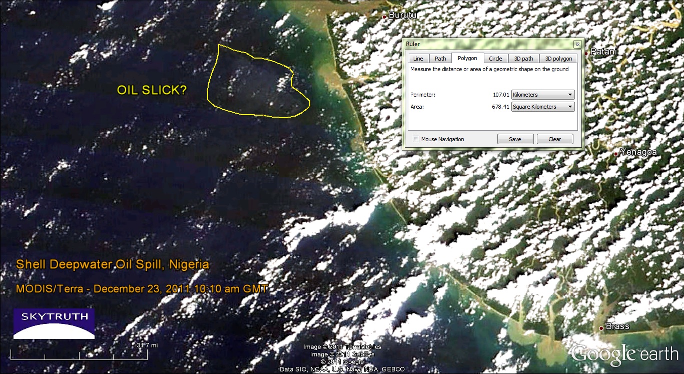
Yesterday's MODIS satellite images were a bust, but today's were slightly less cloudy/hazy.  Both the Terra and Aqua images show a pale patch of ocean water about 18 kilometers offshore, covering a total area of about 678 square kilometers.  But this is a tough call - the image quality really isn't very good.  The closest sizable populated area near this part of the coast, according to Google Earth, is the town of Burutu located at top center on this graphic:
MODIS/Terra satellite image taken December 23, 2011 at 10:10am local time. Possible location of oil slick noted. Image data courtesy NASA/MODIS Rapid Response Team.
This fuzzy patch that may or may not be the remnants of the oil slick is located about where we would expect to see it, given the wind speed and direction over the past couple of days (blowing from the south-southwest at 5-10 knots). Radar imagery would give us a better look but we haven't seen any new radar images since December 21.

[[Location:4.554,4.618]]

Wednesday, December 21, 2011

Shell reports Up to 1.7 MIllion Gallon Oil Spill in off Nigerian Coast

Envisat ASAR satellite radar image showing large slick (outlined in yellow) from major oil spill off Niger Delta.  Image courtesy European Space Agency.
Royal Dutch Shell's Nigerian drilling operations in the highly productive Bonga Field were officially brought to a halt yesterday after "less than 40,000 barrels of oil" (1.7 million gallons) were reportedly leaked during a transfer of crude to a tanker. We've just processed a radar satellite image taken this morning (December 21, 2011) of the field, with the spill clearly visible.  Here it is showing the slick outlined in yellow; it is about 70 km (45 miles) long, 17 km (10 miles) wide at it's widest, and covers 923 square kilometers (356 square miles) of ocean: 

Another, much smaller oil slick appears at lower right; this looks like a bilge dump from a passing vessel, not related to the Shell spill.


[[Location:4.554,4.618]]