Showing posts with label oil. Show all posts

Friday, April 5, 2013

Where are the other 650 Barrels of Oil? Shell Reports Pipeline Leak of 700 bbl of crude oil...

On April 4th, Shell reported to the U.S. Coast Guard's National Response Center (NRC) that 700 bbl of crude oil (29,400 gallons) had spilled from a pipeline. However, official Shell statements say that only 50-60 barrels had spilled into Bayou Vince. Where did the other 650 barrels go? Please share and let us know if you have further information on this incident.

[From Fox Business News] An estimated 50 barrels of oil spilled from a pipeline operated by a subsidiary of Royal Dutch Shell PLC (RSDA.LN, RDSA) into a waterway outside Houston, according to the U.S. Coast Guard.

Shell clean-up crews were working to clear the crude out of Vince Bayou, a waterway that connects to the Houston Ship Channel, which leads into the Gulf of Mexico, said Coast Guard Petty Officer Steven Lehman. The spill was contained but the total amount of oil was still being verified, Officer Lehman said.

"That's a very early estimate--things can change," Officer Lehman said.

On April 3, about 700 barrels were found to have leaked from the West Colombia pipeline because of an unknown cause, with up to 60 of those barrels emerging in the bayou, Shell spokeswoman Kim Windon said. The pipeline had been shut down and isolated on March 29 after alarms alerted the company that oil may have leaked from the line.

Write to Ben Lefebvre at ben.lefebvre@dowjones.com
Copyright © 2013 Dow Jones Newswires

http://www.foxbusiness.com/news/2013/04/04/shell-pipeline-spills-oil-into-houston-area-bayou-coast-guard929745/

[[Location:29.1180555555556, -95.3675]]

Friday, November 16, 2012

Fatal Explosion and Fire on Platform in Gulf of Mexico

An explosion and fire has claimed the lives of at least 2 workers on a platform operated by Black Elk Energy about 10 miles off the Louisiana coast. This is in Block 32 of the West Delta lease area. The water depth is about 60 feet. The fire has been extinguished. Two other workers are reported missing, and four have been airlifted to the hospital. No oil spill has been reported.  Black Elk says 28 workers were on the platform, but it was not producing any oil. [Read more...]

[[Location:29.141813,-89.692978]]

Wednesday, December 21, 2011

Shell reports Up to 1.7 MIllion Gallon Oil Spill in off Nigerian Coast

Envisat ASAR satellite radar image showing large slick (outlined in yellow) from major oil spill off Niger Delta.  Image courtesy European Space Agency.
Royal Dutch Shell's Nigerian drilling operations in the highly productive Bonga Field were officially brought to a halt yesterday after "less than 40,000 barrels of oil" (1.7 million gallons) were reportedly leaked during a transfer of crude to a tanker. We've just processed a radar satellite image taken this morning (December 21, 2011) of the field, with the spill clearly visible.  Here it is showing the slick outlined in yellow; it is about 70 km (45 miles) long, 17 km (10 miles) wide at it's widest, and covers 923 square kilometers (356 square miles) of ocean: 

Another, much smaller oil slick appears at lower right; this looks like a bilge dump from a passing vessel, not related to the Shell spill.


[[Location:4.554,4.618]]

Tuesday, November 22, 2011

Campos Basin Oil Spill, Brazil - Slicks Dissipating?

Envisat ASAR image of Campos Basin taken November 22, 2011. Surface winds too strong to reliably detect thin oil slicks. Bright spots are vessels and oil platforms. Image courtesy European Space Agency.

Today's Envisat ASAR satellite radar image of the Campos Basin, covering the location of the Chevron / Transocean oil spill, shows no sign of an oil slick. It was taken at about 9:30 am local time.

However, the wind speed was fairly strong in the area at the time. According to the satellite scatterometer data collected by the ASCAT system, surface winds were blowing at 15-25 knots (8-13 meters per second). This is strong enough to overwhelm very thin oil slicks (the optimum wind speed for detecting slicks on radar images is about 3 - 10 meters per second)

[[Location: -21.901,-39.822]]

Friday, November 18, 2011

Brazil Oil Spill - Well Plugged, Leaks Abating

We are still waiting to get more good satellite imagery of the Chevron / Transocean oil spill in the Campos Basin - it's been cloud-covered since our last image on November 12, so we've been unable to provide any new information.

But we are happy to pass along that Brazilian authorities report the well was plugged yesterday with cement, and the leakage from nearby points on the seafloor is greatly diminished. We expect to see a much smaller oil slick, if any, when we get another good satellite image of the area.

Brazilian Federal Police have launched an investigation into the causes and size of the spill. We hope all of this information becomes public: deepwater drilling is a global business and these were two of the biggest global players, so lessons learned from this incident will apply here in the U.S. too.

[[Location: -21.901,-39.822]]

Tuesday, November 15, 2011

130 Mile Oil Slick from Chevron OIl Spill off Brazil

We've been tracking the oil spill reported off Brazil a few days ago, in the Frade field operated by Chevron in the Campos Basin, Brazil's most productive area of offshore production, and a place where many deepwater technology milestones have been made for offshore oil production.  Chevron claimed the oil slick was being caused by a natural oil seep on the seafloor, but they suspended drilling on a well in the field.  Brazilian authorities quickly disputed that a natural seep was the cause.  And yesterday Chevron admitted the possibility that something went wrong at their drillsite.  According to today's news release from Brazilian authorities, Chevron is trying to kill the well - indicating a loss of well control and blowout. 18 response vessels are on the scene, and Chevron reports the well is leaking about 8,400 - 13,860 gallons  (200 -330 barrels) per day.

MODIS/Aqua satellite image shows growing oil slick in the deepwater Campos Basin off Brazil.  Image taken around midday on November 12, 2011.

[[Location: -21.901,-39.822]]
[[KML:https://docs.google.com/uc?id=0B9UdbG3ddaeCYWVmOTljY2QtNjE4NC00YzMxLTk4MTYtZTJhZGRiODA5NmUx&export=download&hl=en_US]]


Friday, November 11, 2011

56 Mile Oil Slick Observed off Brazil

Today's MERIS satellite image (courtesy of the European Space Agency) shows an apparent slick that's now about 56 miles long off the coast of Brazil in the Campos Basin:
MERIS satellite image showing slick in Campos Basin off Brazil, November 11, 2011. Image courtesy European Space Agency.
As in the MODIS images shot two days ago, this slick appears to be continuously emanating from a point source at the north end. Today Chevron claimed it was being caused by a natural oil seep, not any leak or problem associated with the offshore field that they operate. 

It is possible, but call us skeptical.  From my previous years working as an exploration geologist I know there are natural seeps off Brazil (that was a study I did for BP back in the day...). But I've never seen a natural seep create a slick this large on a satellite image.


[[Location: -22.117926, -39.664834]]

Thursday, November 10, 2011

Oil Spill off Brazil Seen On Satellite Images

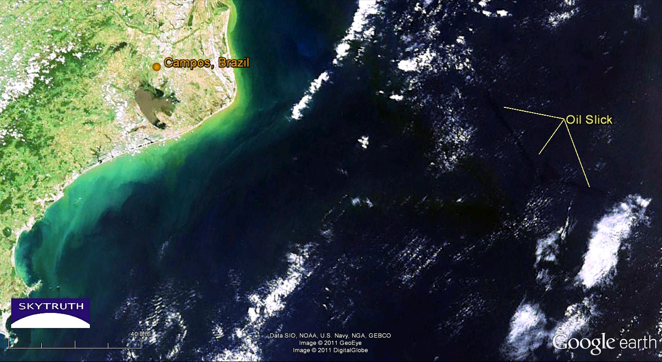
We don't have much information on this yet but Chevron is reporting an oil spill in their Frade field in the Campos Basin off Brazil.  Two MODIS satellite images from NASA, taken yesterday, show an apparent oil slick about 35 miles long and covering about 180 square kilometers, 80 miles offshore due east of the city of Campos. Assuming this slick is only one micron (1/1000th of a millimeter) thick, then it represents about 47,000 gallons.


November 9, 2011 MODIS/Terra image of oil slick off Campos, Brazil. Image courtesy NASA/Rapid Response Team.


[[Location: -22.117926, -39.664834]]