Showing posts with label Chevron. Show all posts

Thursday, March 22, 2012

Slicks in Campos Basin, Offshore Brazil - March 20, 2012

This Envisat ASAR radar satellite image of the Campos Basin, taken at 9:18 pm local time on March 20, shows what appear to be long, narrow slicks emanating from several Petrobras production platforms and FPSOs:
March 201, 2012 Envisat ASAR radar satellite image courtesy European Space Agency.
This is a complex image.  Platforms, FPSOs, drill rigs and vessels appear as bright spots on radar. The large, indistinct dark areas in the upper part of the image are also slicks, but not caused by oil (a "slick" is any patch of smooth water, appearing dark on a radar image). Instead, these patches are probably caused by areas of very low wind speed, and/or by heavy rainfall.  Sea-surface wind data, taken almost the same time as the radar image above, indicate there was unsettled stormy weather in the area. 


[[Location:-22.593539,-40.188575]]

Friday, March 16, 2012

Chevron Reports Minor Slick From Leak in Campos Basin, Offshore Brazil

Chevron and Brazilian regulators reported that a small, fresh oil slick has appeared near the site of Chevron's blowout last November in the deepwater Frade oil field in Brazil's prolific Campos Basin. This is not entirely unexpected given the nature of the problem that Chevron had with the well being drilled by the SEDCO 706 rig: an unknown amount of oil escaped laterally from the well into surrounding bedrock, and worked its way up to the seafloor along a pre-existing natural fault.  It will take some time for all of that oil to emerge, so we've been anticipating chronic small oil slicks at this location.

But optical satellite imagery of this area (MODIS and MERIS) have had problems with clouds and haze for the past few days, so we haven't seen any sign of the latest slick. Radar images don't have that problem, but the most recent radar image we have was taken at about 9pm local time on March 9, and it looks clean around the SEDCO 706 site:


Detail from radar satellite image taken March 9, 2012, showing area of reported Chevron leak. Envisat ASAR image courtesy European Space Agency.
[READ MORE...]

 [[Location:-21.889431,-39.833091]]

Thursday, March 8, 2012

Fire Extinguishes Itself at Chevron Blowout off Nigeria

Chevron reports the fire in the ocean off Nigeria, blazing since their Funiwa-1A gas exploration well blowout occurred on January 16, finally went out on March 2.  It's likely that the well "bridged over" and plugged itself, shutting off the flow of natural gas that had been feeding the fire, something every driller hopes for when they lose control of a well. 

Work will continue on a relief well so that the failed Funiwa-1A well can be properly plugged and abandoned.

We don't see any signs of the fire on today's MODIS/Terra satellite image.

 [[Location:4.356583,5.784562]]

Monday, February 27, 2012

Small Slick at Chevron's Blowout off Nigeria

Chevron's gas-well blowout in the Funiwa field off Nigeria continues to burn as efforts are underway to drill a relief well.  This Envisat ASAR satellite radar image taken today (February 27) shows a small slick apparently emanating from the site where the doomed KS Endeavor rig was drilling. We've seen a small slick repeatedly at this area since the blowout occurred.  Possibly there are some petroleum liquids coming up with the gas, and not completely burning off.  The slick on today's image is about 10 miles long:

Small slick apparently emanating from location of Chevron's Funiwa-1A gas well blowout.  Envisat ASAR image taken February 27, 2012.  Image courtesy European Space Agency.
 [[Location:4.356583,5.784562]]

Wednesday, February 8, 2012

Teri noticed a small slick on today's Envisat ASAR radar satellite image covering the site of Chevron's blowout and fire off the coast of Nigeria. We measure it at about 18.6 kilometers long, extending about 39 square kilometers.  It appears to be very thin.  Assuming the slick is, on average, one micron thick, that amounts to about 9,500 gallons of some oily substance -- possibly unburned natural gas condensate, since this was reported by Chevron to be a gas exploration well that was not creating any oil slick:

Detail from Envisat ASAR image taken February 8, 2012. Location of blowout marked by rig symbol.  Image courtesy European Space Agency.


 [READ MORE]


[[Location:4.356583,5.784562]]

Monday, February 6, 2012

Chevron Blowout and Fire Continues off Nigeria

NASA/MODIS satellite imagery taken yesterday shows that the blowout and fire at a Chevron gas well off the coast of Nigeria continues.  That's 20 days and counting.  It will take weeks to drill a relief well; according to Chevron the Transocean relief rig is on site, and drilling should begin soon.

Chevron "has moved food and supplies to the communities in the area to recognize the help and support that they have given the company."

MODIS-Terra satellite image of Niger Delta showing fire from Chevron offshore well blowout (red spot at center).  Image taken February 5, 2012.  Courtesy NASA/MODIS Rapid Response Team.


   [[Location:4.356583,5.784562]]

Friday, January 20, 2012

Chevron Blowout and Rig Fire off Nigeria - Small Slick Visible on Radar Today

The K.S. Endeavor jackup drill rig operated for Chevron in shallow water about 5 miles off the coast of the Niger Delta is continuing to burn.  This blowout probably won't be under control until a relief well can be drilled. Chevron confirms the rig had been drilling a gas exploration well they call the Funiwa Deep-A, with a planned depth of 16,500 feet.  But the well had only reached a depth of 12,945' when the blowout occurred early Monday morning.  That's comparable to the depth of BP's Macondo well that blew out in the Gulf of Mexico in 2010, launching what would become the world's worst accidental oil spill.

The Funiwa field has both oil and gas reservoirs.  A big question on everyone's mind:  Could this lead to a major oil spill?  Is there a lot of oil already coming out of the well right now, fueling this blowtorch of a fire?  Some have reported sighting slicks and sheen in the vicinity.

Satellite imagery gives us some reason for optimism so far.  This Envisat ASAR radar satellite image taken today shows only a very small slick around what we infer to be the location of the burning Endeavor, based on multiple observations of the fire itself on MODIS 7-2-1 satellite images and the bright spots on the radar image that indicate big hunks of metal out in the water (rigs, vessels, platforms):

Detail from Envisat ASAR image taken January 20, 2012 showing small slicks in vicinity of burning K.S. Endeavor drill rig.  Inferred location of rig shown. Large dark patches along the coast are probably caused by turbid river water entering the ocean.  Image courtesy European Space Agency.
[READ MORE]

  [[Location:4.337242,5.780993]]

Tuesday, January 17, 2012

Satellite Image Shows Heat From Chevron Drill Rig Fire, Offshore Nigeria

K.S. Endeavor jackup drilling rig burning off Nigeria's coast on January 16, 2012. Photo courtesy Chevron.
We've been following reports of a drill rig on fire off the coast of Nigeria, working for Chevron in the Funiwa field. We've also been collecting satellite imagery of the site.  Yesterday's MODIS images had a big data gap right over this area, so we didn't get a chance to see this until today. Here's what it looked like this morning from space, captured by NASA's MODIS sensor on the Terra satellite, in the 7-2-1 rendering that includes the mid-infrared wavelengths.  There is a bright red dot located approximately where we think the rig was working (we could use a more precise location if anyone has it).  This indicates strong emission from the middle-infrared part of the spectrum (band 7), typical for very hot fires:
Detail of MODIS 7-2-1 infrared image along Niger Delta coastline, January 17, 2012.  Bright red spot marks inferred location of the burning K.S. Endeavor jackup drill rig.

[READ MORE]

 [[Location:4.352748,5.783680]]

Tuesday, November 22, 2011

Campos Basin Oil Spill, Brazil - Slicks Dissipating?

Envisat ASAR image of Campos Basin taken November 22, 2011. Surface winds too strong to reliably detect thin oil slicks. Bright spots are vessels and oil platforms. Image courtesy European Space Agency.

Today's Envisat ASAR satellite radar image of the Campos Basin, covering the location of the Chevron / Transocean oil spill, shows no sign of an oil slick. It was taken at about 9:30 am local time.

However, the wind speed was fairly strong in the area at the time. According to the satellite scatterometer data collected by the ASCAT system, surface winds were blowing at 15-25 knots (8-13 meters per second). This is strong enough to overwhelm very thin oil slicks (the optimum wind speed for detecting slicks on radar images is about 3 - 10 meters per second)

[[Location: -21.901,-39.822]]

Friday, November 18, 2011

Brazil Oil Spill - Well Plugged, Leaks Abating

We are still waiting to get more good satellite imagery of the Chevron / Transocean oil spill in the Campos Basin - it's been cloud-covered since our last image on November 12, so we've been unable to provide any new information.

But we are happy to pass along that Brazilian authorities report the well was plugged yesterday with cement, and the leakage from nearby points on the seafloor is greatly diminished. We expect to see a much smaller oil slick, if any, when we get another good satellite image of the area.

Brazilian Federal Police have launched an investigation into the causes and size of the spill. We hope all of this information becomes public: deepwater drilling is a global business and these were two of the biggest global players, so lessons learned from this incident will apply here in the U.S. too.

[[Location: -21.901,-39.822]]

Tuesday, November 15, 2011

130 Mile Oil Slick from Chevron OIl Spill off Brazil

We've been tracking the oil spill reported off Brazil a few days ago, in the Frade field operated by Chevron in the Campos Basin, Brazil's most productive area of offshore production, and a place where many deepwater technology milestones have been made for offshore oil production.  Chevron claimed the oil slick was being caused by a natural oil seep on the seafloor, but they suspended drilling on a well in the field.  Brazilian authorities quickly disputed that a natural seep was the cause.  And yesterday Chevron admitted the possibility that something went wrong at their drillsite.  According to today's news release from Brazilian authorities, Chevron is trying to kill the well - indicating a loss of well control and blowout. 18 response vessels are on the scene, and Chevron reports the well is leaking about 8,400 - 13,860 gallons  (200 -330 barrels) per day.

MODIS/Aqua satellite image shows growing oil slick in the deepwater Campos Basin off Brazil.  Image taken around midday on November 12, 2011.

[[Location: -21.901,-39.822]]
[[KML:https://docs.google.com/uc?id=0B9UdbG3ddaeCYWVmOTljY2QtNjE4NC00YzMxLTk4MTYtZTJhZGRiODA5NmUx&export=download&hl=en_US]]


Friday, November 11, 2011

56 Mile Oil Slick Observed off Brazil

Today's MERIS satellite image (courtesy of the European Space Agency) shows an apparent slick that's now about 56 miles long off the coast of Brazil in the Campos Basin:
MERIS satellite image showing slick in Campos Basin off Brazil, November 11, 2011. Image courtesy European Space Agency.
As in the MODIS images shot two days ago, this slick appears to be continuously emanating from a point source at the north end. Today Chevron claimed it was being caused by a natural oil seep, not any leak or problem associated with the offshore field that they operate. 

It is possible, but call us skeptical.  From my previous years working as an exploration geologist I know there are natural seeps off Brazil (that was a study I did for BP back in the day...). But I've never seen a natural seep create a slick this large on a satellite image.


[[Location: -22.117926, -39.664834]]

Thursday, November 10, 2011

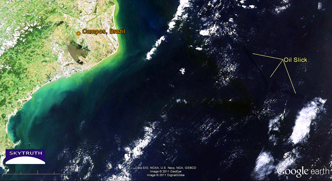
Oil Spill off Brazil Seen On Satellite Images

We don't have much information on this yet but Chevron is reporting an oil spill in their Frade field in the Campos Basin off Brazil.  Two MODIS satellite images from NASA, taken yesterday, show an apparent oil slick about 35 miles long and covering about 180 square kilometers, 80 miles offshore due east of the city of Campos. Assuming this slick is only one micron (1/1000th of a millimeter) thick, then it represents about 47,000 gallons.


November 9, 2011 MODIS/Terra image of oil slick off Campos, Brazil. Image courtesy NASA/Rapid Response Team.


[[Location: -22.117926, -39.664834]]