Showing posts with label FPSO. Show all posts

Friday, March 16, 2012

Chevron Reports Minor Slick From Leak in Campos Basin, Offshore Brazil

Chevron and Brazilian regulators reported that a small, fresh oil slick has appeared near the site of Chevron's blowout last November in the deepwater Frade oil field in Brazil's prolific Campos Basin. This is not entirely unexpected given the nature of the problem that Chevron had with the well being drilled by the SEDCO 706 rig: an unknown amount of oil escaped laterally from the well into surrounding bedrock, and worked its way up to the seafloor along a pre-existing natural fault.  It will take some time for all of that oil to emerge, so we've been anticipating chronic small oil slicks at this location.

But optical satellite imagery of this area (MODIS and MERIS) have had problems with clouds and haze for the past few days, so we haven't seen any sign of the latest slick. Radar images don't have that problem, but the most recent radar image we have was taken at about 9pm local time on March 9, and it looks clean around the SEDCO 706 site:


Detail from radar satellite image taken March 9, 2012, showing area of reported Chevron leak. Envisat ASAR image courtesy European Space Agency.
[READ MORE...]

 [[Location:-21.889431,-39.833091]]

Wednesday, February 1, 2012

Oil Spill from FPSO in Santos Basin, Brazil

Brazil has suffered another oil spill related to FPSO operations, this time in deep water in the Santos Basin. Last week a spill occurred at the Osorio terminal while Campos Basin oil was being offloaded from a shuttle tanker, and fouled the beach near Tramandai. Yesterday, Petrobras reported a spill of about 6700 gallons from the riser pipe of an FPSO in the Santos Basin, forcing them to shut down the country's fifth-most productive oil well. 

[[Location:-25.527500,-43.437833]]

Friday, January 27, 2012

Brazil just experienced another oil spill, this time close enough to shore that it has fouled a stretch of beach in Rio Grande do Sul.  The spill apparently happened while a tanker was offloading a cargo of oil at the Osorio terminal operated by Petrobras, near the city of Tramandai.

The spill was reported to be about 315 gallons.  Video and photos from the affected beaches show one hell of a mess.  I guess a little really goes a long way when it comes to an oil spill:


This spill is reminiscent of Shell's recent spill off Nigeria caused when oil leaked from a cracked transfer line between an FPSO and a shuttle tanker. It's possible this Petrobras spill happened at the other end of an FPSO operation, where the shuttle tanker was offloading its cargo to a coastal facility. This is a concern, since FPSOs are now being used in US waters in the Gulf of Mexico for deepwater oil development -- and Petrobras, the world leader in FPSOs, has already had a serious failure at the first FPSO installation under construction in the Gulf.

[READ MORE...]

[[Location:-30.011879,-50.095181]]

Friday, December 23, 2011

Shell Oil Spill - Moving Toward Nigerian Coast

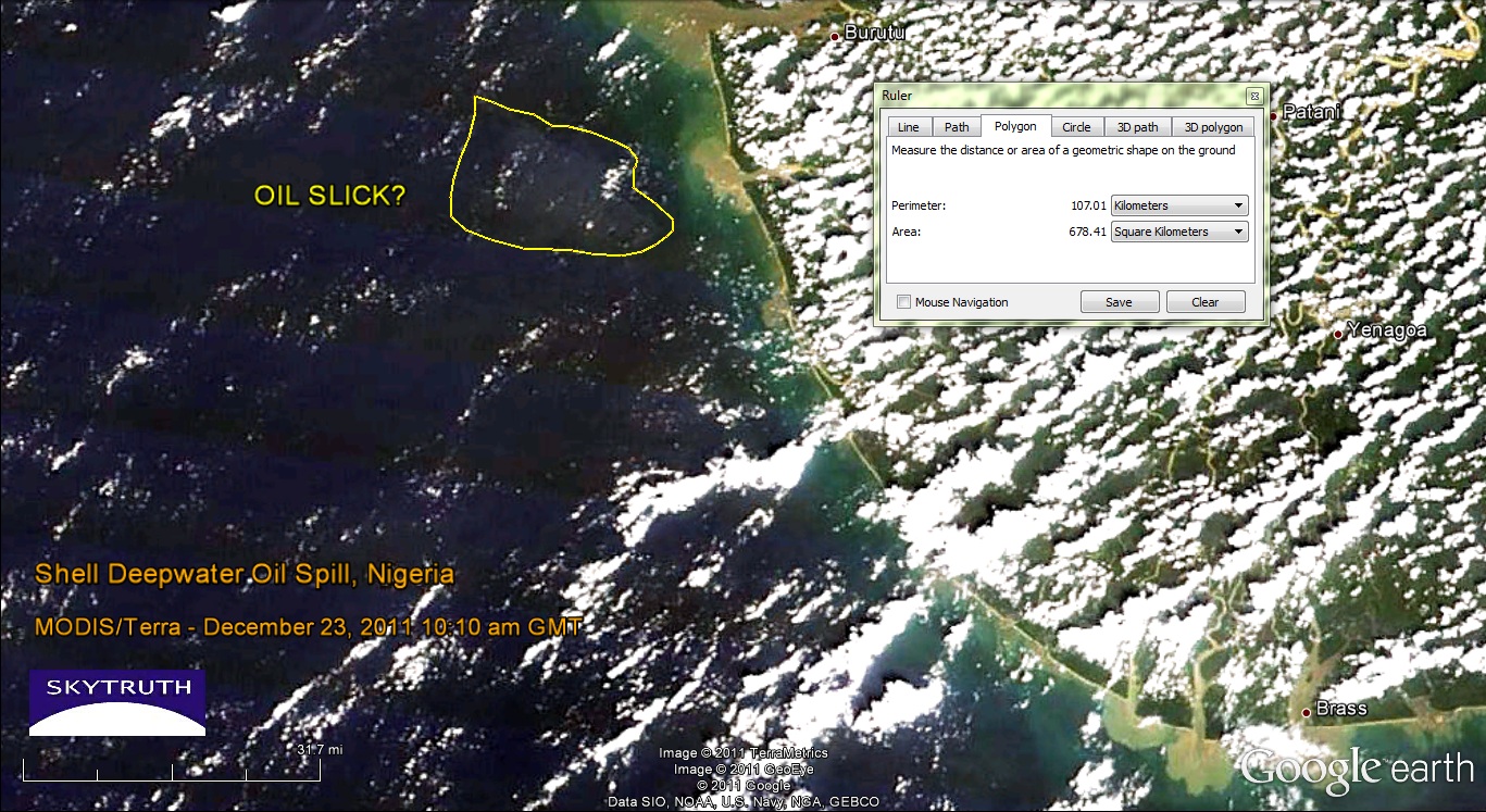
Yesterday's MODIS satellite images were a bust, but today's were slightly less cloudy/hazy.  Both the Terra and Aqua images show a pale patch of ocean water about 18 kilometers offshore, covering a total area of about 678 square kilometers.  But this is a tough call - the image quality really isn't very good.  The closest sizable populated area near this part of the coast, according to Google Earth, is the town of Burutu located at top center on this graphic:
MODIS/Terra satellite image taken December 23, 2011 at 10:10am local time. Possible location of oil slick noted. Image data courtesy NASA/MODIS Rapid Response Team.
This fuzzy patch that may or may not be the remnants of the oil slick is located about where we would expect to see it, given the wind speed and direction over the past couple of days (blowing from the south-southwest at 5-10 knots). Radar imagery would give us a better look but we haven't seen any new radar images since December 21.

[[Location:4.554,4.618]]