This morning we saw a brief news report
noting that Indian authorities reported a "small" oil spill from an
offshore pipeline off the coast of Mumbai. This pipe carries oil ashore
from one of India's largest producing oil fields, the Mumbai (Bombay) High field. It's not the first time this pipeline has had problems.
This MODIS/Terra satellite image taken on October 8, 2013
clearly shows oil slicks in the Arabian Sea scattered throughout a
66-mile-long northwest-trending belt ranging about 50 to 100 miles
offshore. We don't know for sure if these slicks are related to the
pipeline spill. We've seen smaller slicks
in the area in the past, from other causes. But these slicks seem to
be generally in the right area to correspond to this recent pipeline
problem, and their alignment is compatible with the wind blowing from the northwest.
If anyone can provide an accurate latitude/longitude coordinate for the
exact location of the pipeline failure, that would be very helpful. [READ MORE...]
[[Location:19.214057,71.671054]]
This blog is the publishing outlet for alerts about ongoing environmental incidents and pollution events
Showing posts with label oil spill. Show all posts
Tuesday, October 8, 2013
Tuesday, September 3, 2013
Suspected Bilge Dumping off Corsica
| Landsat-8 image (inset) showing two parallel slicks off Corsica. Image taken September 2, 2013. |
[READ MORE...]
[[Location:42.668970,8.475454]]
Friday, July 19, 2013
Slick in Eugene Island Area, Gulf of Mexico - July 18, 2013
A Landsat-8 image taken yesterday
shows a small, unreported slick in the Eugene Island area about 26
kilometers (15 miles) from the Louisiana coast. About 10 km (6 mi)
across, the slick covers about 33 km2. Using our rule of thumb that, to
be visible, a slick must be at least 1 micron thick on average, that
amounts to about 8,700 gallons of oil or some oily substance:
READ MORE....
[[Location:29.255927,-91.701613]]
READ MORE....
[[Location:29.255927,-91.701613]]
Friday, April 5, 2013
Where are the other 650 Barrels of Oil? Shell Reports Pipeline Leak of 700 bbl of crude oil...
On April 4th, Shell reported to the U.S. Coast Guard's National Response Center (NRC) that 700 bbl of crude oil (29,400 gallons) had spilled from a pipeline. However, official Shell statements say that only 50-60 barrels had spilled into Bayou Vince. Where did the other 650 barrels go? Please share and let us know if you have further information on this incident.
[From Fox Business News] An estimated 50 barrels of oil spilled from a pipeline operated by a subsidiary of Royal Dutch Shell PLC (RSDA.LN, RDSA) into a waterway outside Houston, according to the U.S. Coast Guard.
Shell clean-up crews were working to clear the crude out of Vince Bayou, a waterway that connects to the Houston Ship Channel, which leads into the Gulf of Mexico, said Coast Guard Petty Officer Steven Lehman. The spill was contained but the total amount of oil was still being verified, Officer Lehman said.
"That's a very early estimate--things can change," Officer Lehman said.
On April 3, about 700 barrels were found to have leaked from the West Colombia pipeline because of an unknown cause, with up to 60 of those barrels emerging in the bayou, Shell spokeswoman Kim Windon said. The pipeline had been shut down and isolated on March 29 after alarms alerted the company that oil may have leaked from the line.
Write to Ben Lefebvre at ben.lefebvre@dowjones.com
Copyright © 2013 Dow Jones Newswires
http://www.foxbusiness.com/news/2013/04/04/shell-pipeline-spills-oil-into-houston-area-bayou-coast-guard929745/
[[Location:29.1180555555556, -95.3675]]
Monday, April 1, 2013
Approx. 10,000 barrels of Heavy Crude Spilled in Mayflower, AR
http://www.reuters.com/article/2013/03/31/us-exxon-pipeline-spill-idUSBRE92U00220130331
Exxon Mobil on Sunday continued cleanup of a pipeline spill that spewed thousands of barrels of heavy Canadian crude in Arkansas as opponents of oil sands development latched on to the incident to attack plans to build the Keystone XL line.
Exxon spokesman Alan Jeffers said on Sunday that crews had yet to excavate the area around the pipeline breach, a needed step before the company can estimate how long repairs will take and when the line might restart.
"I can't speculate on when it will happen," Jeffers said. "Excavation is necessary as part of an investigation to determine the cause of the incident."
Exxon's Pegasus pipeline, which can carry more than 90,000 barrels per day (bpd) of crude from Patoka, Illinois to Nederland, Texas, was shut after the leak was discovered late Friday afternoon in a subdivision near the town of Mayflower. The leak forced the evacuation of 22 homes.
Exxon also had no specific estimate of how much crude oil had spilled, but the company said 12,000 barrels of oil and water had been recovered - up from 4,500 barrels on Saturday. The company did not say how much of the total was oil and how much was water.
Three NRC reports have been recorded in the Alerts System:
http://alerts.skytruth.org/report/375e75f8-146f-398e-b6cd-d1d83987
http://alerts.skytruth.org/report/5e0b1893-b0d9-3c30-9329-6aa98ef2
http://alerts.skytruth.org/report/97940b9e-982c-3ed7-8130-fa04eba3
[[Location:34.964146, -92.428461]]
March 31, 2013 - [Reuters]:
Exxon Mobil on Sunday continued cleanup of a pipeline spill that spewed thousands of barrels of heavy Canadian crude in Arkansas as opponents of oil sands development latched on to the incident to attack plans to build the Keystone XL line.
Exxon spokesman Alan Jeffers said on Sunday that crews had yet to excavate the area around the pipeline breach, a needed step before the company can estimate how long repairs will take and when the line might restart.
"I can't speculate on when it will happen," Jeffers said. "Excavation is necessary as part of an investigation to determine the cause of the incident."
Exxon's Pegasus pipeline, which can carry more than 90,000 barrels per day (bpd) of crude from Patoka, Illinois to Nederland, Texas, was shut after the leak was discovered late Friday afternoon in a subdivision near the town of Mayflower. The leak forced the evacuation of 22 homes.
Exxon also had no specific estimate of how much crude oil had spilled, but the company said 12,000 barrels of oil and water had been recovered - up from 4,500 barrels on Saturday. The company did not say how much of the total was oil and how much was water.
Three NRC reports have been recorded in the Alerts System:
http://alerts.skytruth.org/report/375e75f8-146f-398e-b6cd-d1d83987
http://alerts.skytruth.org/report/5e0b1893-b0d9-3c30-9329-6aa98ef2
http://alerts.skytruth.org/report/97940b9e-982c-3ed7-8130-fa04eba3
[[Location:34.964146, -92.428461]]
Thursday, March 28, 2013
Support FOIA-Matic: A Tool for Pollution Response Transparency
Want to know what action the government takes when pollution is reported in the Gulf Region? Help us win support from the Knight News Challenge for our FOIA-matic online tool allowing citizens of the Gulf Coast to easily submit Freedom of Information Act (FOIA) requests.
Every day, SkyTruth Alerts users with subscriptions to the Gulf of Mexico get a litany of pollution reports, but now we have a chance at a share of $5 million dollars to build a tool to find out the rest of the story - and we need your help! The BP Gulf Oil Spill in 2010 attracted media attention from all over the world; but what about the dozens of spills, everything from 6 mile-long oil slicks to a few drops of crude oil, that are reported daily to the U.S. Coast Guard's National Response Center (NRC)?
To help citizens to find out how the Coast Guard and Environmental Protection Agency (EPA) responded to pollution reports, we are proposing FOIA-matic, a new feature to be added to Louisiana Bucket Brigade's iWitness Pollution Map and our Gulf Oil Spill Tracker. This simple tool will enable anyone to easily submit a Freedom of Information Act (FOIA) request to the Coast Guard and EPA to find out if there was any response or enforcement to a pollution report.
FOIA-matic, our proposal to the Knight News Challenge on Open Government, is open for feedback until 5 p.m. E.D.T. on Friday, April 29th. Please click the link below and let us know what you think! Offer suggestions how the tool might work, discuss issues the project needs to account for, and let us know how you might benefit from such a tool.
The more feedback and constructive conversation on our entry, the better our chances to win a share of $5 million dollars in funding to build this resource. Providing your comments and applauding our entry requires you to "join the challenge," either by logging in with Facebook or a valid email address, but please take a few minutes to help make this tool a reality!
This post is tagged between the site of the Deepwater Horizon disaster and the chronically leaking Taylor Platform 23051 in order to appear in the Alerts feed of as many of our Gulf Coast subscribers as possible.
[[Location:28.859108, -88.672028]]
This post is tagged between the site of the Deepwater Horizon disaster and the chronically leaking Taylor Platform 23051 in order to appear in the Alerts feed of as many of our Gulf Coast subscribers as possible.
Wednesday, February 27, 2013
Thar She Blows! Another Oil "Geyser" in Gulf of Mexico
According to news accounts and reports coming through the SkyTruth Alerts system, a work boat struck a wellhead in the Gulf of Mexico about 9 miles southwest of Port Sulphur, Louisiana, about 8pm on Tuesday. [NOTE: keep your distance - this well poses a hydrogen sulfide risk.] The well has been intermittently discharging an oily mixture ever since, in a semi-spectacular way judging from this photo provided by the Coast Guard:
This is reminiscent of a similar incident in the Gulf back in August 2010, when an abandoned wellhead in Barataria Bay was also struck by a vessel and spouted oil 100 feet into the air.
[READ MORE...]
[[Location:29.364167,-89.768889]]
![]() |
| Oily geyser erupting from wellhead damaged by a work boat Tuesday. Photo courtesy U.S. Coast Guard. |
[READ MORE...]
[[Location:29.364167,-89.768889]]
Monday, November 12, 2012
Site 23051 - Leaking Oil Into the Gulf Since 2004
We've reported on this site several times since 2010, when we discovered a chronic oil leak in the Gulf of Mexico where a platform operated by Taylor Energy was destroyed by Hurricane Ivan in 2004.
Back in 2010 there was a deepwater drill rig, the Ocean Saratoga, at the site for a while, working to plug the leaking wells. But the rig departed long ago for work elsewhere, and we haven't seen any sign of repair activity there since. Nevertheless, the company reports the continuing leak on a near-daily basis to the National Response Center, and we continue to see the slick on satellite images and during aerial overflights.
Bonny Schumaker of On Wings of Care flew over the Taylor Energy site on Friday (November 9). Scroll down in her blog post to see video and pics of the Taylor oil slick.
To see more info and pics on this chronic pollution source, check out SkyTruth's site chronology and report.
[[Location: 28.938022, -88.970963]]
Back in 2010 there was a deepwater drill rig, the Ocean Saratoga, at the site for a while, working to plug the leaking wells. But the rig departed long ago for work elsewhere, and we haven't seen any sign of repair activity there since. Nevertheless, the company reports the continuing leak on a near-daily basis to the National Response Center, and we continue to see the slick on satellite images and during aerial overflights.
Bonny Schumaker of On Wings of Care flew over the Taylor Energy site on Friday (November 9). Scroll down in her blog post to see video and pics of the Taylor oil slick.
To see more info and pics on this chronic pollution source, check out SkyTruth's site chronology and report.
[[Location: 28.938022, -88.970963]]
Monday, November 5, 2012
Post-Sandy Oil Spill at Motiva Enterprises Oil Teminal, New Jersey
Crews are still working to clean up a major oil spill from the Motiva Enterprises
Sewaren Terminal along the Arthur Kill River in New Jersey. An
estimated 277,000 gallons of diesel fuel were spilled from storage tanks
damaged by Hurricane Sandy at this facility co-owned by Shell. Some of
this oil escaped into a tributary to the Arthur Kill River that
separates New Jersey from Staten Island.
NOAA aerial survey photography taken after the spill gives us a very useful tool for analyzing storm damage, by comparing with pre-spill high-resolution imagery in Google Earth. We've shown some of the severe structural damage and beach erosion revealed by these photos. Now we'll take a look at oil pollution: NOAA air photos shot on November 2 and November 3 show many oil slicks on the Arthur Kill, near marinas and industrial facilities. Some of the slicks are probably from the Motiva spill. We were able to identify two storage tanks on the aerial imagery that were moved off their foundations and partially crumpled. These may be the source of the spill. [READ MORE]
[[Location:40.539691,-74.254345]]
NOAA aerial survey photography taken after the spill gives us a very useful tool for analyzing storm damage, by comparing with pre-spill high-resolution imagery in Google Earth. We've shown some of the severe structural damage and beach erosion revealed by these photos. Now we'll take a look at oil pollution: NOAA air photos shot on November 2 and November 3 show many oil slicks on the Arthur Kill, near marinas and industrial facilities. Some of the slicks are probably from the Motiva spill. We were able to identify two storage tanks on the aerial imagery that were moved off their foundations and partially crumpled. These may be the source of the spill. [READ MORE]
| NOAA aerial imagery showing oil slick at mouth of tributary to the Arthur Kill. |
Wednesday, May 2, 2012
Tanker Collides With Drill Rig Off Corpus Christi, Texas
The FR8 Pride, a Panamax tanker that carries petroleum products, lost power this morning and drifted into a mobile offshore drilling unit - a large jackup drill rig called the Rowan EXL I. The rig was not drilling at the time; it was damaged and has been stabilized. The tanker sustained flooding in a bow compartment and grounded itself; it is carrying a load of fuel oil. No oil spill has been reported. View a video of the collision and aftermath.
[[Location: 27.81753,-96.98905]]
[[Location: 27.81753,-96.98905]]
Thursday, April 12, 2012
Shell Reports 10-Mile-Long Slick in Deepwater Gulf of Mexico
Yesterday evening Shell reported sighting a 10-mile by 1-mile oil
slick between two of their major deepwater oil production platforms, Ursa and Mars. This is located in the Mississippi Canyon area of the
Gulf, 130 miles south of New Orleans and about 60 miles beyond the tip
of the Mississippi Delta, in water about 3,200' deep.
Yesterday's low resolution MODIS/Terra satellite image of the area, shot at 16:50 UTC (10:50 am local time) shows what appears to be a narrow, 17-mile-long slick in the vicinity of the two platforms. We often see slicks from known natural oil seeps that are about this size; some in the Green Canyon area to the west show up well on this same image. Low clouds and their shadows are scattered across the lower half of this view:
[READ MORE...]
[[Location: 28.204381,-89.258767]]
Yesterday's low resolution MODIS/Terra satellite image of the area, shot at 16:50 UTC (10:50 am local time) shows what appears to be a narrow, 17-mile-long slick in the vicinity of the two platforms. We often see slicks from known natural oil seeps that are about this size; some in the Green Canyon area to the west show up well on this same image. Low clouds and their shadows are scattered across the lower half of this view:
[READ MORE...]
[[Location: 28.204381,-89.258767]]
Friday, April 6, 2012
Gas Well Blowout in the North Sea - Small Slick on April 4
The out-of-control well owned by French company Total in the central
North Sea's Elgin field is still spewing natural gas into the air. We noted a small slick at this site
on a radar satellite image taken March 27. Another image, taken on
April 4, also shows a somewhat smaller slick (see image below). This is
probably caused by natural-gas condensate, a volatile and toxic
hydrocarbon liquid that evaporates relatively quickly. We don't see any
reason to expect this incident to morph into a significant oil spill.
[READ MORE...]
[[Location: 57.011667,1.837778]]
| Radar satellite image showing small slick at North Sea blowout site, taken on April 4, 2012 at 9:29 pm local time. Envisat ASAR image courtesy European Space Agency. |
[[Location: 57.011667,1.837778]]
Thursday, April 5, 2012
Cuba Offshore Drilling Rig Spotted on Radar - Small Slick Reported
The big semisubmersible drill rig, built in China and now drilling a
deepwater oil well for the Spanish company Repsol in the Florida Straits
off Cuba (hey, it is a global industry), has finally made an appearance
on a radar satellite image. This Envisat ASAR image,
shot at 11:43 pm local time on March 30, shows a trio of very bright
spots about 17 miles north-northwest of Havana. We think the largest of
these spots, with an interesting cross-shaped "ringing" pattern often seen on radar images of big, boxy metal objects, is the Scarabeo-9 rig. The other two spots may be crew vessels or workboats:
[READ MORE...]
[[Location: 23.374496,-82.492283]]
| Image courtesy European Space Agency. |
[[Location: 23.374496,-82.492283]]
Wednesday, March 28, 2012
Gas Well Blowout in the North Sea
On March 26, Total reported a gas leak that forced them to evacuate more
than 200 workers from a production platform in the Elgin field of the
central North Sea, about 150 miles east of Aberdeen, Scotland. The Oil Drum has compiled excellent information about this serious ongoing incident. This
Envisat ASAR radar satellite image, taken yesterday at about 9:23 pm
local time, shows a patchy slick covering about 89 square kilometers (34 square miles).
The platform itself appears as a very bright spot on the radar image
but it's covered up by our yellow rig icon marking the location:
[READ MORE]
[[Location: 57.011667,1.837778]]
| Envisat ASAR image courtesy European Space Agency. |
[[Location: 57.011667,1.837778]]
Thursday, March 22, 2012
Slicks in Campos Basin, Offshore Brazil - March 20, 2012
This Envisat ASAR radar satellite image of the Campos Basin,
taken at 9:18 pm local time on March 20, shows what appear to be long,
narrow slicks emanating from several Petrobras production platforms and FPSOs:
![]() |
| March 201, 2012 Envisat ASAR radar satellite image courtesy European Space Agency. |
This
is a complex image. Platforms, FPSOs, drill rigs and vessels appear as
bright spots on radar. The large, indistinct dark areas in the upper
part of the image are also slicks, but not caused by oil (a "slick" is
any patch of smooth water, appearing dark on a radar image). Instead,
these patches are probably caused by areas of very low wind speed,
and/or by heavy rainfall. Sea-surface wind data, taken almost the same time as the radar image above, indicate there was unsettled stormy weather in the area.
[[Location:-22.593539,-40.188575]]
Monday, March 19, 2012
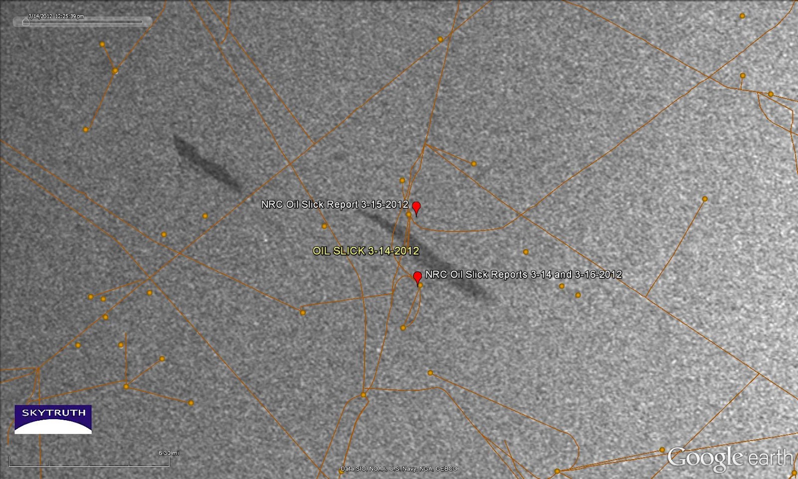
Mystery Slicks in Central Gulf - East Cameron South, Block 321
Every now and then we see something in SkyTruth Alerts
that catches our eye. For the past few days we've noticed repeated
reports of an unknown oil slick sighted near some platforms near Block
321 in the East Cameron (South Addition) area of the central Gulf of
Mexico, about 92 miles off the Louisiana coast. We also see two slicks
in the vicinity on an Envisat ASAR satellite radar image taken about
noon local time on March 14. The slicks aren't particularly big, on the
image or in the reports, but their persistence in the area under strong winds blowing steadily from the southeast
suggests that there is a continuous source of oil leaking at this
site. This is close to a major international shipping lane for the port
of Houston, and there are also quite a few platforms and pipelines in
the neighborhood:
back in 1978). Oil slick sightings were reported to the National Response Center, probably by personnel on the nearby platforms, on March 14, 15 and 16. No source or cause is indicated in the reports. We don't know if there is any active drilling occurring in the area.
If anybody wants to
swing on by and take a look, the center of the slick at right is located
at 28.197404° North latitude / 92.783588° West longitude.
[[Location:28.197404,-92.783588]]
Friday, March 16, 2012
Chevron Reports Minor Slick From Leak in Campos Basin, Offshore Brazil
Chevron and Brazilian regulators reported that a small, fresh oil slick has appeared near the site of Chevron's blowout last November
in the deepwater Frade oil field in Brazil's prolific Campos Basin.
This is not entirely unexpected given the nature of the problem that
Chevron had with the well being drilled by the SEDCO 706 rig: an unknown
amount of oil escaped laterally from the well into surrounding bedrock,
and worked its way up to the seafloor along a pre-existing natural
fault. It will take some time for all of that oil to emerge, so we've
been anticipating chronic small oil slicks at this location.
But optical satellite imagery of this area (MODIS and MERIS) have had problems with clouds and haze for the past few days, so we haven't seen any sign of the latest slick. Radar images don't have that problem, but the most recent radar image we have was taken at about 9pm local time on March 9, and it looks clean around the SEDCO 706 site:
[READ MORE...]
[[Location:-21.889431,-39.833091]]
But optical satellite imagery of this area (MODIS and MERIS) have had problems with clouds and haze for the past few days, so we haven't seen any sign of the latest slick. Radar images don't have that problem, but the most recent radar image we have was taken at about 9pm local time on March 9, and it looks clean around the SEDCO 706 site:
![]() |
| Detail from radar satellite image taken March 9, 2012, showing area of reported Chevron leak. Envisat ASAR image courtesy European Space Agency. |
[[Location:-21.889431,-39.833091]]
Monday, February 27, 2012
Small Slick at Chevron's Blowout off Nigeria
Chevron's gas-well blowout in the Funiwa field off Nigeria continues to burn as efforts are underway to drill a relief well. This Envisat ASAR satellite radar
image taken today (February 27) shows a small slick apparently emanating
from the site where the doomed KS Endeavor rig was drilling.
We've seen a small slick repeatedly at this area since the blowout
occurred. Possibly there are some petroleum liquids coming up with the
gas, and not completely burning off. The slick on today's image is
about 10 miles long:
[[Location:4.356583,5.784562]]
![]() |
| Small slick apparently emanating from
location of Chevron's Funiwa-1A gas well blowout. Envisat ASAR image
taken February 27, 2012. Image courtesy European Space Agency. |
Small Slick at Platform P-51, Marlim Sul Field, Brazil
An Envisat ASAR radar satellite image taken on February 23, 2012 shows a small slick apparently emanating from Platform P-51 in the Marlim Sul field of the Campos Basin, about 70 miles offshore:
Covering 10 square kilometers, this slick represents a
spill of about 2600 gallons, assuming an average oil slick thickness of
1 micron.
[[Location:-22.635572,-40.093169]]
![]() |
| Envisat ASAR image taken February 23, 2012 showing small slick apparently emanating from location of Platform P-51. Image courtesy European Space Agency. |
[[Location:-22.635572,-40.093169]]
Thursday, February 23, 2012
Bilge Dumping off Vietnam - February 22, 2012
We've posted
about bilge dumping before - the practice of flushing the oily slop out
of your vessel, straight into the ocean. It's illegal in a lot of
places, but it is very hard to enforce. SkyTruth's daily offshore
monitoring program just caught this fine (awful?) example of bilge
dumping off the coast of Vietnam, in a major north-south shipping lane
about 115 miles offshore:
Zooming in on those black streaks, and turning the image west-up, here's a closer look at this mess:
[READ MORE...]
[[Location:12.820307,111.724137]]
| Envisat ASAR satellite radar image off Vietnam, February 22, 2012. Image courtesy European Space Agency. |
| Envisat ASAR image courtesy European Space Agency. |
[READ MORE...]
[[Location:12.820307,111.724137]]
Subscribe to:
Posts (Atom)