 |
| Hercules drill rig enveloped by cloud of gas from well blowout, July 23, 2013. Photo by Bonny Schumaker / On Wings of Care flew. See many more on her blog. |
Showing posts with label Louisiana. Show all posts
Showing posts with label Louisiana. Show all posts
Tuesday, July 23, 2013
Gas Blowout at Hercules Drill Rig, Gulf of Mexico
Around midday today a
natural gas blowout occurred at a jackup drill rig, the Hercules 265,
operating in shallow water in the Gulf of Mexico off the coast of
Louisiana (South Timbalier Block 220). All of the workers -- more than
40 -- were safely evacuated. The rig was enveloped in a cloud of gas,
so there is a high risk of fire or explosion until the well is killed. A small sheen was reported around the platform - this is probably a thin
slick of highly volatile natural-gas condensate. At this time we have
no reason to think there is potential for a significant oil spill from
this incident. But, coming hard on the heels of another blowout that happened in the Ship Shoal area last week, it's yet another reminder that drilling is an inherently risky activity.
[[Location:28.384130,-90.530968]]

Friday, July 19, 2013
Slick in Eugene Island Area, Gulf of Mexico - July 18, 2013
A Landsat-8 image taken yesterday
shows a small, unreported slick in the Eugene Island area about 26
kilometers (15 miles) from the Louisiana coast. About 10 km (6 mi)
across, the slick covers about 33 km2. Using our rule of thumb that, to
be visible, a slick must be at least 1 micron thick on average, that
amounts to about 8,700 gallons of oil or some oily substance:
READ MORE....
[[Location:29.255927,-91.701613]]
 |
| Detail from a Landsat-8 satellite image (inset) taken on July 18, 2013, showing a small apparent oil slick (orange outline) in the Eugene Island area off the Louisiana coast. Oil and gas platforms shown as small red dots. |
[[Location:29.255927,-91.701613]]
Wednesday, February 27, 2013
Thar She Blows! Another Oil "Geyser" in Gulf of Mexico
According to news accounts and reports coming through the SkyTruth Alerts system, a work boat struck a wellhead in the Gulf of Mexico about 9 miles southwest of Port Sulphur, Louisiana, about 8pm on Tuesday. [NOTE: keep your distance - this well poses a hydrogen sulfide risk.] The well has been intermittently discharging an oily mixture ever since, in a semi-spectacular way judging from this photo provided by the Coast Guard:
This is reminiscent of a similar incident in the Gulf back in August 2010, when an abandoned wellhead in Barataria Bay was also struck by a vessel and spouted oil 100 feet into the air.
[READ MORE...]
[[Location:29.364167,-89.768889]]
 |
| Oily geyser erupting from wellhead damaged by a work boat Tuesday. Photo courtesy U.S. Coast Guard. |
[READ MORE...]
[[Location:29.364167,-89.768889]]
Friday, November 16, 2012
Fatal Explosion and Fire on Platform in Gulf of Mexico
An explosion and fire
has claimed the lives of at least 2 workers on a platform operated by
Black Elk Energy about 10 miles off the Louisiana coast. This is in
Block 32 of the West Delta lease area. The water depth
is about 60 feet. The fire has been extinguished. Two other workers are reported missing,
and four have been airlifted to the hospital. No oil spill has been
reported. Black Elk says 28 workers were on the platform, but it was not producing any oil. [Read more...]
[[Location:29.141813,-89.692978]]
[[Location:29.141813,-89.692978]]
Monday, November 12, 2012
Site 23051 - Leaking Oil Into the Gulf Since 2004
We've reported on this site several times since 2010, when we discovered a chronic oil leak in the Gulf of Mexico where a platform operated by Taylor Energy was destroyed by Hurricane Ivan in 2004.
Back in 2010 there was a deepwater drill rig, the Ocean Saratoga, at the site for a while, working to plug the leaking wells. But the rig departed long ago for work elsewhere, and we haven't seen any sign of repair activity there since. Nevertheless, the company reports the continuing leak on a near-daily basis to the National Response Center, and we continue to see the slick on satellite images and during aerial overflights.
Bonny Schumaker of On Wings of Care flew over the Taylor Energy site on Friday (November 9). Scroll down in her blog post to see video and pics of the Taylor oil slick.
To see more info and pics on this chronic pollution source, check out SkyTruth's site chronology and report.
[[Location: 28.938022, -88.970963]]
Back in 2010 there was a deepwater drill rig, the Ocean Saratoga, at the site for a while, working to plug the leaking wells. But the rig departed long ago for work elsewhere, and we haven't seen any sign of repair activity there since. Nevertheless, the company reports the continuing leak on a near-daily basis to the National Response Center, and we continue to see the slick on satellite images and during aerial overflights.
Bonny Schumaker of On Wings of Care flew over the Taylor Energy site on Friday (November 9). Scroll down in her blog post to see video and pics of the Taylor oil slick.
To see more info and pics on this chronic pollution source, check out SkyTruth's site chronology and report.
[[Location: 28.938022, -88.970963]]
Thursday, April 12, 2012
Shell Reports 10-Mile-Long Slick in Deepwater Gulf of Mexico
Yesterday evening Shell reported sighting a 10-mile by 1-mile oil
slick between two of their major deepwater oil production platforms, Ursa and Mars. This is located in the Mississippi Canyon area of the
Gulf, 130 miles south of New Orleans and about 60 miles beyond the tip
of the Mississippi Delta, in water about 3,200' deep.
Yesterday's low resolution MODIS/Terra satellite image of the area, shot at 16:50 UTC (10:50 am local time) shows what appears to be a narrow, 17-mile-long slick in the vicinity of the two platforms. We often see slicks from known natural oil seeps that are about this size; some in the Green Canyon area to the west show up well on this same image. Low clouds and their shadows are scattered across the lower half of this view:

[READ MORE...]
[[Location: 28.204381,-89.258767]]
Yesterday's low resolution MODIS/Terra satellite image of the area, shot at 16:50 UTC (10:50 am local time) shows what appears to be a narrow, 17-mile-long slick in the vicinity of the two platforms. We often see slicks from known natural oil seeps that are about this size; some in the Green Canyon area to the west show up well on this same image. Low clouds and their shadows are scattered across the lower half of this view:

[READ MORE...]
[[Location: 28.204381,-89.258767]]
Tuesday, April 10, 2012
Gas Pipeline Explosion and Fire - Vermilion Parish, Louisiana
SkyTruth Alerts
gave us a heads up that there was an explosion and fire around noon
yesterday in the marshes of Vermilion Parish, Louisiana. One caller to
the National Response Center noted flames shooting 150' into the air; another caller, perhaps a bit more excited, claimed 800'. At
about the same time, a caller from Texas Gas Transmission Co. detected a
huge drop in pressure in one of their gas pipelines, while noting a fireball in the marsh in the vicinity of the pipeline. The fire was burning so hot that it shows up as a fuzzy red spot in this low-resolution MODIS/Terra band 7-2-1 satellite image, taken yesterday at 1pm local time:
 |
| MODIS/Terra
721 satellite image, April 9, 2012 showing fire from inferred gas
pipeline rupture in Louisiana. Orange dots are offshore oil and gas
platforms in federal waters; orange lines are some of the seafloor oil
and gas pipelines.
[[Location: 29.23301,-91.035783]]
|
Monday, March 19, 2012
Mystery Slicks in Central Gulf - East Cameron South, Block 321
Every now and then we see something in SkyTruth Alerts
that catches our eye. For the past few days we've noticed repeated
reports of an unknown oil slick sighted near some platforms near Block
321 in the East Cameron (South Addition) area of the central Gulf of
Mexico, about 92 miles off the Louisiana coast. We also see two slicks
in the vicinity on an Envisat ASAR satellite radar image taken about
noon local time on March 14. The slicks aren't particularly big, on the
image or in the reports, but their persistence in the area under strong winds blowing steadily from the southeast
suggests that there is a continuous source of oil leaking at this
site. This is close to a major international shipping lane for the port
of Houston, and there are also quite a few platforms and pipelines in
the neighborhood:
The water depth here is about 200-300 feet (note that a pipeline in this area was damaged during drilling operations back in 1978). Oil slick sightings were reported to the National Response Center, probably by personnel on the nearby platforms, on March 14, 15 and 16. No source or cause is indicated in the reports. We don't know if there is any active drilling occurring in the area.
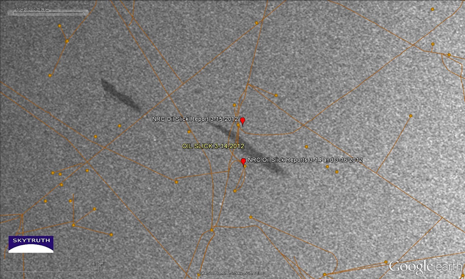 |
| Radar satellite image taken March 14, 2012 showing a pair of small slicks near the vicinity of oil slick sightings reported to the National Response Center on March 14, 15 and 16 (red markers). Orange lines and dots are pipelines and platforms. Image courtesy European Space Agency. |
If anybody wants to
swing on by and take a look, the center of the slick at right is located
at 28.197404° North latitude / 92.783588° West longitude.
[[Location:28.197404,-92.783588]]
Friday, December 16, 2011
Taylor / 23051 Chronic Leak Site in Gulf: Oil Analyzed
Back on September 15, a team from National Wildlife Federation piled onto a small boat on the Louisiana coast. Their destination: the chronic leak site about 12 miles offshore where a cluster of wells operated by Taylor Energy has been steadily spilling oil into the Gulf since 2004. Check out this aerial video of the site, shot by On Wings of Care on December 9, 2011.
Their objective: to collect samples of the Taylor oil slick for analysis, to see if it's chemically distinguishable from the oil that gushed from BP's infamous Macondo well about 30 miles away. We wanted to know if other samples of oil collected in this region of the Gulf, on beaches and barrier islands and from slicks observed offshore, could possibly be coming from the Taylor site since it's a well-documented source of oil pollution.
The upshot: oil leaking from the Taylor site should not easily be confused with relatively unweathered oil from the Macondo disaster. But it would be very helpful to collect more and better samples from the slicks being observed in the vicinity of the Macondo well site. [Read more....]
[[Location: 28.938022, -88.970963]]
Their objective: to collect samples of the Taylor oil slick for analysis, to see if it's chemically distinguishable from the oil that gushed from BP's infamous Macondo well about 30 miles away. We wanted to know if other samples of oil collected in this region of the Gulf, on beaches and barrier islands and from slicks observed offshore, could possibly be coming from the Taylor site since it's a well-documented source of oil pollution.
The upshot: oil leaking from the Taylor site should not easily be confused with relatively unweathered oil from the Macondo disaster. But it would be very helpful to collect more and better samples from the slicks being observed in the vicinity of the Macondo well site. [Read more....]
[[Location: 28.938022, -88.970963]]
Tuesday, October 4, 2011
Beautiful Gulf Image Today - MODIS/Terra
Thought I'd share this pretty satellite image of the Gulf of Mexico, taken at about 10:30 am local time this morning. No sign of the smoke plume we reported on from October 2, which was also visible on yesterday's Terra and Aqua images.
So enjoy. Click to get the larger version, formatted to be 16:9 so it makes a sweet background for most computer monitors...!

So enjoy. Click to get the larger version, formatted to be 16:9 so it makes a sweet background for most computer monitors...!

Tuesday, September 27, 2011
Nighttime Satellite Image of Gulf - September 25, 2011
As part of our investigation into the report of a fire in the Gulf the night of September 25 (at 7:45 pm local time), we got a few recent low-resolution nighttime images taken by satellites of the Defense Meteorological Satellite Program (DMSP). This one was taken at 8:12 pm on the 25th:
Read more.
[[Location: 28.483333, -88.250000]]
 |
| DMSP nighttime satellite image taken at 8:11 pm on September 25, 2011. DMSP image and data processing by NOAA's National Geophysical Data Center. DMSP data collected by the US Air Force Weather Agency. |
[[Location: 28.483333, -88.250000]]
Slick at 23051 Site - September 26, 2011
Yesterday's MODIS/Aqua image shows a slick that appears to emanate from our old nemesis, the former platform 23051 site that has been leaking since 2004. The apparent slick is about 20 miles long and covers about 115 square kilometers. Assuming an average thickness of 1 micron (1/1000th of a millimeter), that's 30,705 gallons of oil. If this slick is at the lower limit of visible detection, 0.1 microns, it's still 3,000 gallons - which is 3,000 times bigger than Taylor reported yesterday to the National Response Center just 30 minutes after this image was taken:
Read more.
[[Location: 28.938022, -88.970963]]
[[KML: https://docs.google.com/leaf?id=0B9UdbG3ddaeCNzMxOGQ4ZjgtMTM0OC00YjZlLTllNGQtZTRmYmYxMDEwNzBm&hl=en_US]]
 |
| Detail from MODIS/Aqua image, September 26, 2011 showing apparent slick (delineated in yellow) emanating from 23051 site. |
Read more.
[[Location: 28.938022, -88.970963]]
[[KML: https://docs.google.com/leaf?id=0B9UdbG3ddaeCNzMxOGQ4ZjgtMTM0OC00YjZlLTllNGQtZTRmYmYxMDEwNzBm&hl=en_US]]
Monday, September 26, 2011
Fire Reported in Gulf of Mexico
This just caught our eye on the SkyTruth Alerts: multiple aircraft flying over the Gulf have reported seeing a fire about 60 miles southeast of the tip of the Mississippi Delta, in deep water about 20 miles south-southeast of BP's failed Macondo well. The source of the fire is unknown, and to our knowledge this report has not been verified. But the location given in the NRC report puts this in Mississippi Canyon Block 519, where wells have recently been drilled by Noble Energy and tied back to the massive "Na Kika" platform located in Block 474 a few miles to the northwest. A few small spills of hydraulic fluid have been reported in the vicinity in the past week so we know there is current activity in the area. Read more.
[[Location: 28.483333, -88.250000]]
 |
| Location of fire reported late last night in Gulf of Mexico. |
Subscribe to:
Posts (Atom)