We've been routinely watching the coast of Nigeria for oil spills (like the recent ExxonMobil offshore pipeline spill that's affected 20 miles of coastline)
and other incidents. Lately we've noticed what appears to be something
burning far offshore, approximately 75 miles southwest of Brass on the
Niger Delta. We went back as far as July on MODIS satellite images to
see what we could find, and we did find evidence of burning going on
multiple times over the past few months at that location, as you can see
in the images below.
Is this continuous flaring (the
burning off of unwanted natural gas) from a deepwater oil production
platform, or from a drill rig? Does anybody know who is currently
operating out there? Any help "sea-truthing" this site would be greatly appreciated!
The location is 3.477568° North latitude, 5.569900° East longitude.
[READ MORE...]
[[Location:3.477568,5.569900]]
Showing posts with label Nigeria. Show all posts
Showing posts with label Nigeria. Show all posts
Monday, December 3, 2012

Thursday, March 8, 2012
Fire Extinguishes Itself at Chevron Blowout off Nigeria
Chevron reports the fire in the ocean off Nigeria, blazing since their Funiwa-1A gas exploration well blowout occurred on January 16, finally went out on March 2. It's likely that the well "bridged over" and plugged itself, shutting off the flow of natural gas that had been feeding the fire, something every driller hopes for when they lose control of a well.
Work will continue on a relief well so that the failed Funiwa-1A well can be properly plugged and abandoned.
We don't see any signs of the fire on today's MODIS/Terra satellite image.
[[Location:4.356583,5.784562]]
Work will continue on a relief well so that the failed Funiwa-1A well can be properly plugged and abandoned.
We don't see any signs of the fire on today's MODIS/Terra satellite image.
[[Location:4.356583,5.784562]]
Monday, February 27, 2012
Small Slick at Chevron's Blowout off Nigeria
Chevron's gas-well blowout in the Funiwa field off Nigeria continues to burn as efforts are underway to drill a relief well. This Envisat ASAR satellite radar
image taken today (February 27) shows a small slick apparently emanating
from the site where the doomed KS Endeavor rig was drilling.
We've seen a small slick repeatedly at this area since the blowout
occurred. Possibly there are some petroleum liquids coming up with the
gas, and not completely burning off. The slick on today's image is
about 10 miles long:
[[Location:4.356583,5.784562]]
 |
| Small slick apparently emanating from
location of Chevron's Funiwa-1A gas well blowout. Envisat ASAR image
taken February 27, 2012. Image courtesy European Space Agency. |
Wednesday, February 8, 2012
Teri noticed a small slick on today's Envisat ASAR radar satellite image covering the site of Chevron's blowout and fire
off the coast of Nigeria. We measure it at about 18.6 kilometers long,
extending about 39 square kilometers. It appears to be very thin.
Assuming the slick is, on average, one micron thick, that amounts to
about 9,500 gallons of some oily substance -- possibly unburned natural
gas condensate, since this was reported by Chevron to be a gas exploration well that was not creating any oil slick:
[READ MORE]
[[Location:4.356583,5.784562]]
 |
| Detail from Envisat ASAR image taken February 8, 2012. Location of blowout marked by rig symbol. Image courtesy European Space Agency. |
[READ MORE]
[[Location:4.356583,5.784562]]
Monday, February 6, 2012
Chevron Blowout and Fire Continues off Nigeria
NASA/MODIS satellite imagery taken yesterday shows that the blowout and fire at a Chevron gas well off the coast of Nigeria continues. That's 20 days and counting. It will take weeks to drill a relief well; according to Chevron the Transocean relief rig is on site, and drilling should begin soon.
Chevron "has moved food and supplies to the communities in the area to recognize the help and support that they have given the company."
Chevron "has moved food and supplies to the communities in the area to recognize the help and support that they have given the company."
 |
| MODIS-Terra
satellite image of Niger Delta showing fire from Chevron offshore well
blowout (red spot at center). Image taken February 5, 2012. Courtesy
NASA/MODIS Rapid Response Team.
[[Location:4.356583,5.784562]]
|
Friday, January 20, 2012
Chevron Blowout and Rig Fire off Nigeria - Small Slick Visible on Radar Today
The K.S. Endeavor jackup drill rig operated for Chevron in
shallow water about 5 miles off the coast of the Niger Delta is
continuing to burn. This blowout probably won't be under control until a
relief well can be drilled. Chevron confirms
the rig had been drilling a gas exploration well they call the Funiwa
Deep-A, with a planned depth of 16,500 feet. But the well had only
reached a depth of 12,945' when the blowout occurred early Monday
morning. That's comparable to the depth of BP's Macondo well that blew
out in the Gulf of Mexico in 2010, launching what would become the
world's worst accidental oil spill.
The Funiwa field has both oil and gas reservoirs. A big question on everyone's mind: Could this lead to a major oil spill? Is there a lot of oil already coming out of the well right now, fueling this blowtorch of a fire? Some have reported sighting slicks and sheen in the vicinity.
Satellite imagery gives us some reason for optimism so far. This Envisat ASAR radar satellite image taken today shows only a very small slick around what we infer to be the location of the burning Endeavor, based on multiple observations of the fire itself on MODIS 7-2-1 satellite images and the bright spots on the radar image that indicate big hunks of metal out in the water (rigs, vessels, platforms):
[READ MORE]
[[Location:4.337242,5.780993]]
The Funiwa field has both oil and gas reservoirs. A big question on everyone's mind: Could this lead to a major oil spill? Is there a lot of oil already coming out of the well right now, fueling this blowtorch of a fire? Some have reported sighting slicks and sheen in the vicinity.
Satellite imagery gives us some reason for optimism so far. This Envisat ASAR radar satellite image taken today shows only a very small slick around what we infer to be the location of the burning Endeavor, based on multiple observations of the fire itself on MODIS 7-2-1 satellite images and the bright spots on the radar image that indicate big hunks of metal out in the water (rigs, vessels, platforms):
 |
| Detail from Envisat ASAR image taken January 20, 2012 showing small slicks in vicinity of burning K.S. Endeavor drill rig. Inferred location of rig shown. Large dark patches along the coast are probably caused by turbid river water entering the ocean. Image courtesy European Space Agency. |
[[Location:4.337242,5.780993]]
Tuesday, January 17, 2012
Satellite Image Shows Heat From Chevron Drill Rig Fire, Offshore Nigeria
 |
| K.S. Endeavor jackup drilling rig burning off Nigeria's coast on January 16, 2012. Photo courtesy Chevron. |
 |
| Detail of MODIS 7-2-1 infrared image along Niger Delta coastline, January 17, 2012. Bright red spot marks inferred location of the burning K.S. Endeavor jackup drill rig. |
[READ MORE]
[[Location:4.352748,5.783680]]
Friday, December 23, 2011
Shell Oil Spill - Moving Toward Nigerian Coast
Yesterday's MODIS satellite images were a bust, but today's were
slightly less cloudy/hazy. Both the Terra and Aqua images show a pale
patch of ocean water about 18 kilometers offshore, covering a total area
of about 678 square kilometers. But this is a tough call - the image
quality really isn't very good. The closest sizable populated area near
this part of the coast, according to Google Earth, is the town of
Burutu located at top center on this graphic:
This fuzzy patch that may or may not be the remnants
of the oil slick is located about where we would expect to see it, given
the wind speed and direction over the past couple of days (blowing from the south-southwest at 5-10 knots). Radar imagery would give us a better look but we haven't seen any new radar images since December 21.
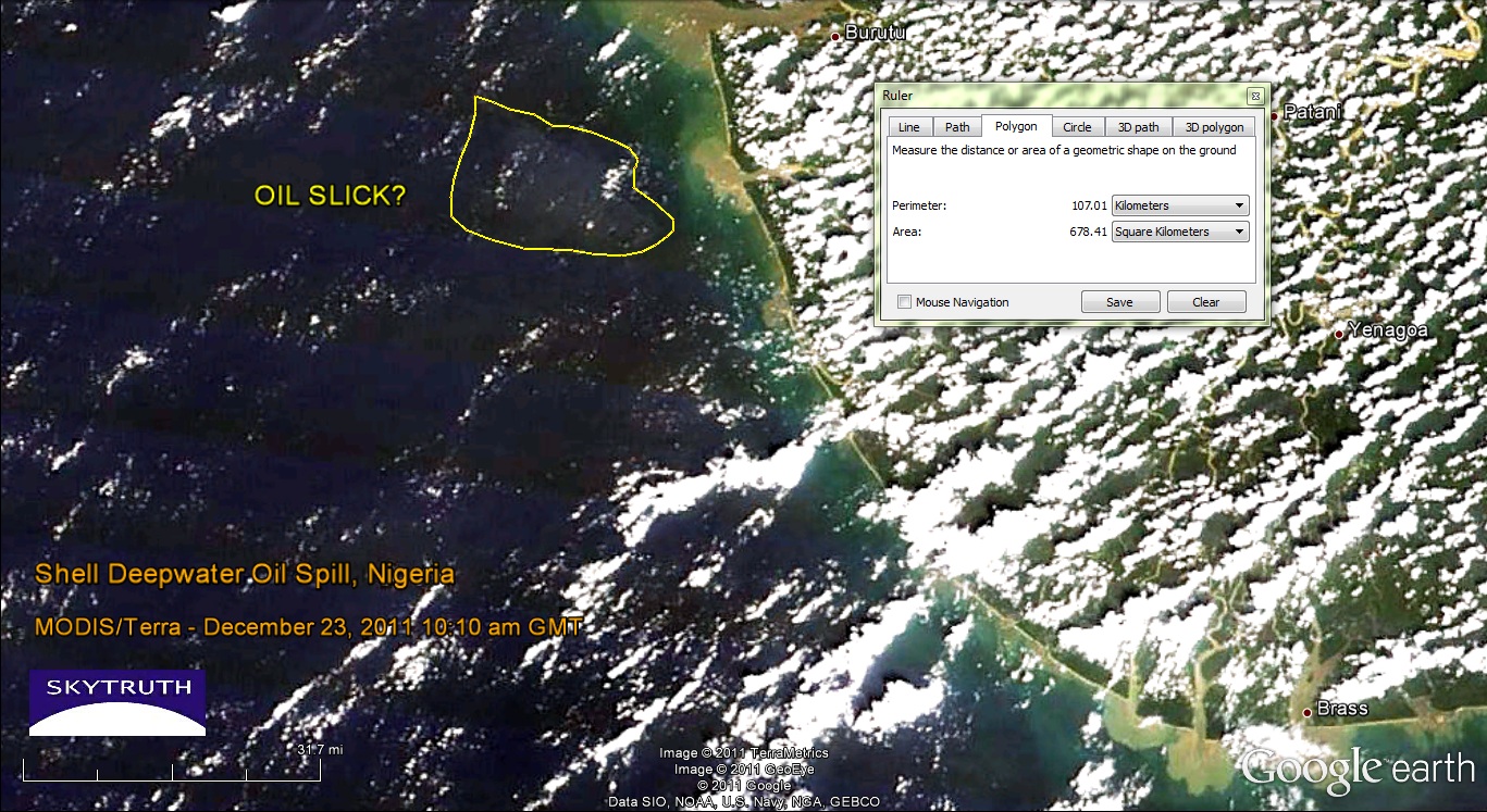 |
| MODIS/Terra satellite image taken December 23, 2011 at 10:10am local time. Possible location of oil slick noted. Image data courtesy NASA/MODIS Rapid Response Team. |
[[Location:4.554,4.618]]
Subscribe to:
Posts (Atom)