Friday, January 27, 2012

Brazil just experienced another oil spill, this time close enough to shore that it has fouled a stretch of beach in Rio Grande do Sul.  The spill apparently happened while a tanker was offloading a cargo of oil at the Osorio terminal operated by Petrobras, near the city of Tramandai.

The spill was reported to be about 315 gallons.  Video and photos from the affected beaches show one hell of a mess.  I guess a little really goes a long way when it comes to an oil spill:


This spill is reminiscent of Shell's recent spill off Nigeria caused when oil leaked from a cracked transfer line between an FPSO and a shuttle tanker. It's possible this Petrobras spill happened at the other end of an FPSO operation, where the shuttle tanker was offloading its cargo to a coastal facility. This is a concern, since FPSOs are now being used in US waters in the Gulf of Mexico for deepwater oil development -- and Petrobras, the world leader in FPSOs, has already had a serious failure at the first FPSO installation under construction in the Gulf.

[READ MORE...]

[[Location:-30.011879,-50.095181]]

Wednesday, January 25, 2012

Drilling to Begin Soon in Deep Water Off Cuba

Say hello to my little friend:  Scarabeo-9 arrives to begin deepwater drilling off Cuba.  Photo courtesy Shipspotting.com.

The Scarabeo-9, a big semisubmersible drill rig owned by Italian company ENI, just built in China, and currently under contract to the Spanish oil company Repsol, has arrived in the Florida Straits off the north coast of Cuba to begin exploratory oil drilling.  The rig will begin its work in exploration block N27 (see map after the jump) just 90 miles from Key West, in water about 6,500' deep.  That's 1,500' deeper than the site of the BP / Deepwater Horizon spill in the Gulf in 2010. 

[READ MORE...]

[[Location:23.541403,82.223840]]

Friday, January 20, 2012

Chevron Blowout and Rig Fire off Nigeria - Small Slick Visible on Radar Today

The K.S. Endeavor jackup drill rig operated for Chevron in shallow water about 5 miles off the coast of the Niger Delta is continuing to burn.  This blowout probably won't be under control until a relief well can be drilled. Chevron confirms the rig had been drilling a gas exploration well they call the Funiwa Deep-A, with a planned depth of 16,500 feet.  But the well had only reached a depth of 12,945' when the blowout occurred early Monday morning.  That's comparable to the depth of BP's Macondo well that blew out in the Gulf of Mexico in 2010, launching what would become the world's worst accidental oil spill.

The Funiwa field has both oil and gas reservoirs.  A big question on everyone's mind:  Could this lead to a major oil spill?  Is there a lot of oil already coming out of the well right now, fueling this blowtorch of a fire?  Some have reported sighting slicks and sheen in the vicinity.

Satellite imagery gives us some reason for optimism so far.  This Envisat ASAR radar satellite image taken today shows only a very small slick around what we infer to be the location of the burning Endeavor, based on multiple observations of the fire itself on MODIS 7-2-1 satellite images and the bright spots on the radar image that indicate big hunks of metal out in the water (rigs, vessels, platforms):

Detail from Envisat ASAR image taken January 20, 2012 showing small slicks in vicinity of burning K.S. Endeavor drill rig.  Inferred location of rig shown. Large dark patches along the coast are probably caused by turbid river water entering the ocean.  Image courtesy European Space Agency.
[READ MORE]

  [[Location:4.337242,5.780993]]

Tuesday, January 17, 2012

Satellite Image Shows Heat From Chevron Drill Rig Fire, Offshore Nigeria

K.S. Endeavor jackup drilling rig burning off Nigeria's coast on January 16, 2012. Photo courtesy Chevron.
We've been following reports of a drill rig on fire off the coast of Nigeria, working for Chevron in the Funiwa field. We've also been collecting satellite imagery of the site.  Yesterday's MODIS images had a big data gap right over this area, so we didn't get a chance to see this until today. Here's what it looked like this morning from space, captured by NASA's MODIS sensor on the Terra satellite, in the 7-2-1 rendering that includes the mid-infrared wavelengths.  There is a bright red dot located approximately where we think the rig was working (we could use a more precise location if anyone has it).  This indicates strong emission from the middle-infrared part of the spectrum (band 7), typical for very hot fires:
Detail of MODIS 7-2-1 infrared image along Niger Delta coastline, January 17, 2012.  Bright red spot marks inferred location of the burning K.S. Endeavor jackup drill rig.

[READ MORE]

 [[Location:4.352748,5.783680]]

Friday, December 23, 2011

Shell Oil Spill - Moving Toward Nigerian Coast

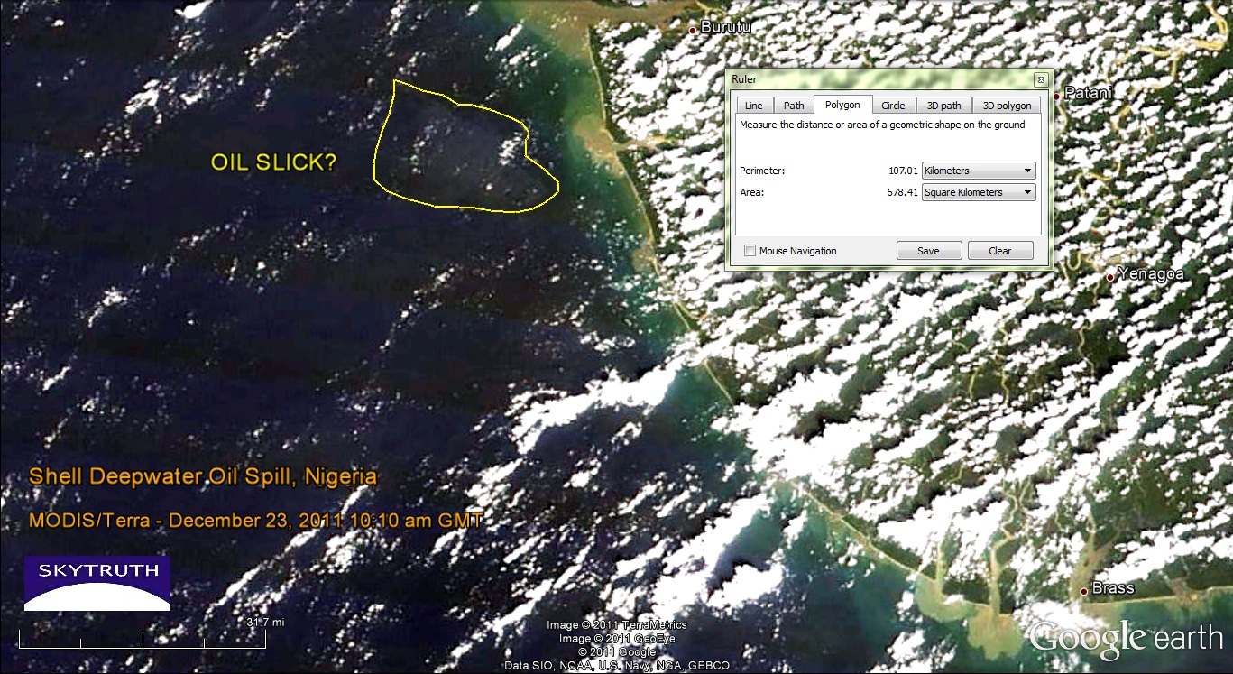
Yesterday's MODIS satellite images were a bust, but today's were slightly less cloudy/hazy.  Both the Terra and Aqua images show a pale patch of ocean water about 18 kilometers offshore, covering a total area of about 678 square kilometers.  But this is a tough call - the image quality really isn't very good.  The closest sizable populated area near this part of the coast, according to Google Earth, is the town of Burutu located at top center on this graphic:
MODIS/Terra satellite image taken December 23, 2011 at 10:10am local time. Possible location of oil slick noted. Image data courtesy NASA/MODIS Rapid Response Team.
This fuzzy patch that may or may not be the remnants of the oil slick is located about where we would expect to see it, given the wind speed and direction over the past couple of days (blowing from the south-southwest at 5-10 knots). Radar imagery would give us a better look but we haven't seen any new radar images since December 21.

[[Location:4.554,4.618]]

Wednesday, December 21, 2011

Shell reports Up to 1.7 MIllion Gallon Oil Spill in off Nigerian Coast

Envisat ASAR satellite radar image showing large slick (outlined in yellow) from major oil spill off Niger Delta.  Image courtesy European Space Agency.
Royal Dutch Shell's Nigerian drilling operations in the highly productive Bonga Field were officially brought to a halt yesterday after "less than 40,000 barrels of oil" (1.7 million gallons) were reportedly leaked during a transfer of crude to a tanker. We've just processed a radar satellite image taken this morning (December 21, 2011) of the field, with the spill clearly visible.  Here it is showing the slick outlined in yellow; it is about 70 km (45 miles) long, 17 km (10 miles) wide at it's widest, and covers 923 square kilometers (356 square miles) of ocean: 

Another, much smaller oil slick appears at lower right; this looks like a bilge dump from a passing vessel, not related to the Shell spill.


[[Location:4.554,4.618]]

Friday, December 16, 2011

Envisat ASAR radar image taken December 6, 2011. Image courtesy European Space Agency - click for larger version.
The radar satellite image above, taken on December 6, 2011, shows a very small slick originating near the location of Transocean's SEDCO 706 drilling rig that was installing Chevron's failed well. The slick is about 7.3 miles long and a few hundred yard wide, comparable to the slicks created by natural oil seeps in the Gulf of Mexico.  Wind conditions were good for slick detection at the time, blowing at about 10 knots (5 meters per second).  Several other small slicks are visible near a cluster of oil platforms (bright spots) about 50 miles south of the SEDCO 706.  This is within the southern Campos Basin, and these slicks may be the result of minor spills or leaks from platforms, pipelines, or vessels operating in one of the many offshore fields in the region. [Read more...]
 
[[Location: -21.901,-39.822]]