Monday, June 23, 2014

Heavy Oil in the Water at Taylor Energy Site #23051 [Photos and Video]

Our partners at On Wings of Care and Florida State University have been out skytruthing and seatruthing heavy oil on the water around the downed Taylor Energy Platform #23051. We have been tracking this ongoing leak that has persisted in the Gulf of Mexico since 2004, but lately the oil has been particularly prominent. 

You can see aerial photos and photos from sea level here:


 and here:


You can also click here to download a recent Landsat satellite image that shows the oil slick.


NOTE: On the satellite image, the green streaks in the water are most likely a type of seaweed known as sargassum. But the bluish-grey smears SE of the Delta is oil.

We do not have the most recent NRC reports due to the shutdown of the public side of the NRC website. You can usually access the reports updated weekly from our temporary work-around here...


[[Location: 28.938022, -88.970963]]

Tuesday, June 3, 2014

Oil Spill in Delta National Wildlife Refuge - Controlled Burn Planned

From the National Response Center: (May 28, 2014)

**THIS IS AN UPDATE TO REPORT NUMBER 1084160, THE AMOUNT HAS CHANGED.** CALLER IS REPORTING A DISCHARGE OF APPROXIMATELY 15 BARRELS OF CRUDE OIL INTO A MARSH AREA INSIDE THE DELTA NATIONAL WILDLIFE REFUGE FROM A 4" SUBMERGED OUT OF SERVICE FLOW LINE. CAUSE IS UNDER INVESTIGATION.

From The Times- Picayune: (June 2, 2014)

http://www.nola.com/environment/index.ssf/2014/06/authorities_work_to_contain_50.html#incart_river_default

By Ken Daley, NOLA.com | The Times-Picayune
on June 02, 2014 at 8:37 PM, updated June 02, 2014 at 8:52 PM

Officials from the U.S. Fish and Wildlife Service and U.S. Coast Guard announced Monday they were working to mitigate damage from a spill of crude oil within the Delta National Wildlife Refuge.

The agencies reported that a silver sheen of oil was spotted by an aerial overflight last Wednesday (May 28). An investigation determined the source of the crude oil discharge was a leaky bulk line buried under the surface of the marsh and that the Houston-based Texas Petroleum Investment Company was the responsible party.

Officials estimated the leak's volume as equivalent to about 50 barrels. They said an estimated 10 acres of fresh-water marsh in a remote section of the refuge was impacted, in an area located about 10 miles southeast of Venice in
 Plaquemines Parish. Access to the area was said to be difficult, with cleanup crews limited to flat-bottomed boats once inclement weather had passed.

Officials said a controlled burn would be ignited Tuesday to reduce the amount of oil in the marsh and accelerate cleanup operations. Refuge manager Neil Lalonde said airboats and scare cannons would be deployed to temporarily disperse wildlife, but that the controlled burn would be closely monitored and have minimal impact on avian, wildlife and marine species.

Lalonde said Octave Pass would be temporarily closed to mariners during the burn, but would be reopened after its conclusion.

[[Location:29.245556, -89.199167]]

Thursday, February 13, 2014

Train Carrying Canadian Crude Oil and Propane Derails in Vandergrift, Pa.

Via WPXI - http://www.wpxi.com/news/news/breaking-news-train-derailment-vandergrift/ndM5K/

VANDERGRIFT, Pa. — A train hauling crude oil and propane derailed in Vandergrift, Westmoreland County, Thursday morning.

More than 21 cars on a Norfolk Southern rail line between Vandergrift and East Vandergrift derailed around 8:30 a.m.   One of the cars torpedoed into the MSI Corporation.

“The lights were shaking and everything was going out.  All the lights were going out,” said MSI Corporation employee Greg Shotts.

People inside the MSI Corporation building were evacuated.

Engineers were sent to examine the structural integrity of the damaged building.

“MSI Company has been evacuated due to the one car going into their building. Until the structural integrity of the building is determined to be safe, we will refrain from putting anyone back into that building,” Stevens said. “There’s no evacuation planned as of right now. If an evacuation is to occur, we will let you know as soon as we have that information.”

Northfolk Southern estimated thousands of gallons of crude oil leaked from four tank cars.

It wasn’t immediately clear what was leaking.

“If it’s leaking, we’re kind of screwed because it’s sitting in the middle of town,” said Lorenda Banks.

Officials said it could take days to completely clear the area.

Norfolk Southern released a statement Thursday afternoon saying, ”A 120-car Norfolk Southern train derailed 21 rail cars at Vandergrift, Pa., about 20 miles NE of Pittsburgh at 8 a.m. today [Thursday].

"Nineteen of the derailed cars contained heavy crude oil and two cars contained LPG gas. Four cars were leaking crude oil, but the leaks from each of the cars have been stopped. Norfolk Southern has an environmental team on site with the clean-up of an estimated 3,000-4000 gallons of crude oil.

"During the derailment some of the rail cars struck a building which fabricates metal products, and at least one of the cars is in the building.

"The train was transporting a variety of products, including Canadian heavy crude oil, LPG, soda ash, and food products. The train originated in Chicago and its final destination was Paulsboro, N.J.”


Westmoreland County Emergency Management spokesman Dan Stevens said no injuries were reported.

[[location:40.603871,-79.555459]]

Tuesday, February 11, 2014

Appalachian Water Watch Alert - Patriot Coal Slurry Spill

From Appalachian Voices - http://appalachianwaterwatch.org/2014-patriot-slurry-spill-wv/

On early Tuesday morning a coal slurry leak into Fields Creek was reported from Patriot Coal’s Kanawha Eagle Operation, which is located in eastern Kanawha County.

Ken Ward Jr. from the Charleston Gazette reports, “Dale Petry, director of emergency services for Kanawha County, said that an eight-inch slurry line between the preparation plant and the company’s refuse impoundment ruptured, sending an underdetermined amount of coal waste into the creek before the flow was stopped.’I would probably characterize it as a significant spill, but I don’t have a figure yet,” said Aluise, the DEP spokesman.’”


Patriot’s New West Hollow slurry impoundments (Photo: Bing maps)

For the entire article, click here.

The Appalachian Water Watch team is on its way to investigate the incident and will continue reporting what we find.

For the latest official reports and citizen reports, visit the Appalachian Water Watch system - a SkyTruth tool built for Appalachian Voices to track spills and empower citizens: 


[[Location:38.162,-81.564]]

Large Explosion in Western North Dakota

From Valley News Live - http://www.valleynewslive.com/story/24690824/large-explosion-in-western-north-dakota

State and local officials are investigating a large explosion and fire reported Monday night in western North Dakota.


Video of a large fire was posted on YouTube Tuesday morning.

The Williams County Sheriff's Department says, the incident happened south of Tioga at a well site near Highway 2 and County Road 21. It was reported about 8:30 Monday night.

The Tioga Fire Department responded to the scene.

So far there are no reports of injuries. The cause of the explosion is under investigation.

SKYTRUTH NOTE: This alert is geotagged to what appears to be a compressor station which fits the above description. Additionally, two infrared detections were picked up within 750 meters from this facility by the VIIRS instrument aboard the Suomi NPP satellite. This is area that has not shown much flaring activity in recent months, so the detections could be associated with the fire and explosion.

[[Location:48.331312,-102.914]]

1 injured, 1 missing at Greene County gas well fire: Chevron - Lanco 7H Well


From WTAE Pittsburg - UPDATED 12:51 PM EST Feb 11, 2014

DUNKARD TOWNSHIP, Pa. —One worker has been injured and another is missing after a natural gas well explosion and fire in southwestern Pennsylvania, within miles of the West Virginia border


Chevron spokesman Trip Oliver says the fire was reported at about 6:45 a.m. at the Lanco 7H well in Dunkard Township, near Bobtown.

Chevron spokesman Trip Oliver says the fire was reported at about 6:45 a.m. at the Lanco 7H well in Dunkard Township, near Bobtown. That's about 50 miles south of Pittsburgh. Oliver says one person is reported hospitalized and another is currently unaccounted for.


Oliver says Chevron personnel immediately responded to the fire and called in assistance from Wild Well Control.

Ambulance and emergency medical crews have been summoned to the scene, and state police have reportedly set up a half-mile perimeter.

Crews at the scene report that intense flames have kept them from getting too close to the well.

Stay with WTAE.com for updates. Watch the latest report during our live webcast of Channel 4 Action News at noon.

Read more: http://www.wtae.com/news/local/explosion-reported-at-gas-well-in-greene-county/24407710#ixzz2t2PeYb6K

[[Location:39.761897,-80.007689]]

Monday, February 3, 2014

Duke Energy Plant In Eden, NC Reports Coal-Ash Spill

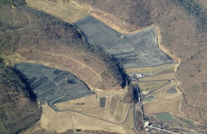
From the Charlotte Observer - http://www.charlotteobserver.com/2014/02/03/4661193/duke-energy-plant-reports-coal.html#.UvAnhnmaap-

Duke Energy said Monday that an unknown amount of coal ash and water was released from a pond at its retired Dan River power plant in Eden into the Dan River.

Duke said a stormwater pipe beneath the unlined ash pond broke Sunday afternoon. Water and ash from the 27-acre pond, which holds 155 million gallons at full capacity, drained into the pipe.

Jamie Kritzer, spokesman for the N.C. Department of Environment and Natural Resources said shortly before 6 p.m. Monday that Duke engineers had temporarily stopped the flow into the river as they work toward a permanent fix.

“Engineers are working to estimate the volume of water and ash that reached the river, and the company will provide that detail when it is confirmed,” Duke said in an afternoon release. Duke expects to release an estimate Monday night, spokeswoman Erin Culbert said.

The Dan River plant is about 130 miles northeast of Charlotte near the Virginia line.

The pond’s dam beside the river “remains secure,” Duke said. Some erosion has occurred on the side of a berm farthest from the river, it said, and engineers are working to stabilize it.

Independent engineers who inspected the pond’s dam in 2009 for the Environmental Protection Agency found it in good condition, but noted some seepage and recommended a stability study on the structure’s river side. Built in 1956, it was divided into two ponds in the 1970s.

The Dan River plant was retired in 2012, so the level of ash and water in the pond was a lower level than when the plant operated, Duke said. A security guard spotted an unusually low water level in the ash pond at about 2 p.m. Sunday, leading to the discovery of the pipe break.

Duke said it has dispatched a team to monitor the river’s water quality. Coal ash contains metals that can be toxic in high concentrations.

Ash was visible on the banks of the Dan River, and the water was tinted gray.

The city of Danville, Va., whose water intake is about six miles downstream of the pond, said Monday the ash has not posed problems.

Barry Dunkley, the city’s water director, said in a release that “all water leaving our treatment facility has met public health standards. We do not anticipate any problems going forward in treating the water we draw from the Dan River.”

The Dan River plant was retired in 2012, so the level of ash and water in the pond was a lower level, Duke said.

Staff from the Winston-Salem office of the N.C. environment department were taking water samples to monitor the river’s health.

“While it is early in the investigation and state officials do not yet know of any possible impacts to water quality, staff members have been notifying downstream communities with drinking water intakes,” the department said late Monday afternoon.

A massive spill of ash slurry at a Tennessee Valley Authority power plant in Tennessee in 2008 ignited national debate over coal ash.

Last week the EPA, which had been sued by two N.C. environmental groups among others, said it would issue the first federal rules on ash-handling by December.

Duke has closed seven of its 14 N.C. coal-fired power plants, including Dan River, and is evaluating ways to close the ash ponds at those sites. Groundwater contamination has been found around all 14 of its unlined ash ponds, although much of the contamination may occur naturally.

North Carolina environment officials, pressured by advocacy groups, sued Duke last year over ash handling at all its coal plants. Environmentalists say Duke should remove the ash from the retired ponds, as utilities in South Carolina have agreed to do.

[[Location:36.489834,-79.715102]]

Thursday, January 9, 2014

Chemical Spill in Elk River near Charleston, WV - Drinking Water Advisory in Kanawha, Boone, Clay, Jackson, Lincoln, Logan, Putnam and Roane Counties

West Virginia chemical spill prompts state of emergency, water ban in 8 counties

By Becky Bratu, Staff Writer, NBC News

West Virginia Gov. Earl Ray Tomblin declared a state of emergency Thursday in several counties because of a chemical spill into the Elk River. 

The advisory was expanded at night from five to eight counties.

The state of emergency includes West Virginia American Water customers in Kanawha, Boone, Clay, Jackson, Lincoln, Logan, Putnam and Roane counties, according to NBC station WSAZ.

Residents were told not to drink the water, bathe in it or cook with the water and only use it for flushing and fire emergencies. Boiling it will not remove the chemicals. 

The station said the chemical leaked from a tank at Freedom Industries in Charleston. The leaked product is 4-methylcyclohexane methanol, which is used in the froth flotation process of coal washing and preparation, according to WSAZ.

Freedom Industries did not immediately respond for comment.


[[Location:38.368730,-81.606668]]

NOTE: Due to a technical glitch, this input into the Alerts system did not automatically integrated into Alerts subscriber's feeds. The NRC report was also picked up late due to inadequate location data. See that report submitted by a third-party at:

http://alerts.skytruth.org/report/8d34bfc0-3b9a-3808-98fb-a795a611188e

Friday, January 3, 2014

Fire (?) in Campos Basin Off Coast of Brazil

MODIS/Aqua satellite imagery of the coast of Brazil taken on December 31 shows what appears to be a long plume of smoke in the Atlantic Ocean about 70 miles from shore in the Campos Basin. The plume appears to emanate from a point about 2.7 miles north-northeast of Petrobras Platform 51, a big semisubmersible rig in the Marlim Sul field. VIIRS data indicate the presence of a combustion source at the north end of the smoke plume, and estimate it's temperature is 1800 degrees Kelvin -- hot enough to soften steel. The plume visibly extends to the south for at least 146 miles.

MODIS/Aqua satellite image taken December 31, 2013, showing apparent smoke plume emanating from Campos Basin off Brazil. Red markers indicate sources of combustion detected by nighttime satellite imagery; orange dots are locations of oil platforms (2011 data).


It's possible this is just an unusually vigorous gas-flaring event, but we don't see comparable plumes of smoke from the many other flares detected in the area.  We haven't heard anything but are concerned there may be a fire at a platform or drill rig working at this location.  Please let us know if you have any information!

[READ MORE...]

[[Location:-22.600214, -40.068569]]