We've been routinely watching the coast of Nigeria for oil spills (like the recent ExxonMobil offshore pipeline spill that's affected 20 miles of coastline)
and other incidents. Lately we've noticed what appears to be something
burning far offshore, approximately 75 miles southwest of Brass on the
Niger Delta. We went back as far as July on MODIS satellite images to
see what we could find, and we did find evidence of burning going on
multiple times over the past few months at that location, as you can see
in the images below.
Is this continuous flaring (the
burning off of unwanted natural gas) from a deepwater oil production
platform, or from a drill rig? Does anybody know who is currently
operating out there? Any help "sea-truthing" this site would be greatly appreciated!
The location is 3.477568° North latitude, 5.569900° East longitude.
[READ MORE...]
[[Location:3.477568,5.569900]]
Monday, December 3, 2012
Friday, November 16, 2012
Fatal Explosion and Fire on Platform in Gulf of Mexico
An explosion and fire
has claimed the lives of at least 2 workers on a platform operated by
Black Elk Energy about 10 miles off the Louisiana coast. This is in
Block 32 of the West Delta lease area. The water depth
is about 60 feet. The fire has been extinguished. Two other workers are reported missing,
and four have been airlifted to the hospital. No oil spill has been
reported. Black Elk says 28 workers were on the platform, but it was not producing any oil. [Read more...]
[[Location:29.141813,-89.692978]]
[[Location:29.141813,-89.692978]]
Monday, November 12, 2012
Small (But Common?) Oil Leak in East Bay off Mississippi Delta
Bonny Schumaker,
tireless pilot and Gulf pollution watchdog, flew out over East Bay on
Saturday (yes, she also flew the notorious Taylor Energy chronic leak
site just the day before). Sure enough, she spotted a leak from one of
the platforms in East Bay. Here's her video, and a few pics of the
leak. Aside from Bonny's report, this particular incident apparently hasn't been reported to the NRC as required by law.
[Read more with pics and video]
[[Location: 28.998579,-89.281001]]
 |
| Oily leak in East Bay on November 10, 2012. Photo courtesy Bonny Schumaker. |
[[Location: 28.998579,-89.281001]]
Site 23051 - Leaking Oil Into the Gulf Since 2004
We've reported on this site several times since 2010, when we discovered a chronic oil leak in the Gulf of Mexico where a platform operated by Taylor Energy was destroyed by Hurricane Ivan in 2004.
Back in 2010 there was a deepwater drill rig, the Ocean Saratoga, at the site for a while, working to plug the leaking wells. But the rig departed long ago for work elsewhere, and we haven't seen any sign of repair activity there since. Nevertheless, the company reports the continuing leak on a near-daily basis to the National Response Center, and we continue to see the slick on satellite images and during aerial overflights.
Bonny Schumaker of On Wings of Care flew over the Taylor Energy site on Friday (November 9). Scroll down in her blog post to see video and pics of the Taylor oil slick.
To see more info and pics on this chronic pollution source, check out SkyTruth's site chronology and report.
[[Location: 28.938022, -88.970963]]
Monday, November 5, 2012
Post-Sandy Oil Spill at Motiva Enterprises Oil Teminal, New Jersey
Crews are still working to clean up a major oil spill from the Motiva Enterprises
Sewaren Terminal along the Arthur Kill River in New Jersey. An
estimated 277,000 gallons of diesel fuel were spilled from storage tanks
damaged by Hurricane Sandy at this facility co-owned by Shell. Some of
this oil escaped into a tributary to the Arthur Kill River that
separates New Jersey from Staten Island.
NOAA aerial survey photography taken after the spill gives us a very useful tool for analyzing storm damage, by comparing with pre-spill high-resolution imagery in Google Earth. We've shown some of the severe structural damage and beach erosion revealed by these photos. Now we'll take a look at oil pollution: NOAA air photos shot on November 2 and November 3 show many oil slicks on the Arthur Kill, near marinas and industrial facilities. Some of the slicks are probably from the Motiva spill. We were able to identify two storage tanks on the aerial imagery that were moved off their foundations and partially crumpled. These may be the source of the spill. [READ MORE]
[[Location:40.539691,-74.254345]]
NOAA aerial survey photography taken after the spill gives us a very useful tool for analyzing storm damage, by comparing with pre-spill high-resolution imagery in Google Earth. We've shown some of the severe structural damage and beach erosion revealed by these photos. Now we'll take a look at oil pollution: NOAA air photos shot on November 2 and November 3 show many oil slicks on the Arthur Kill, near marinas and industrial facilities. Some of the slicks are probably from the Motiva spill. We were able to identify two storage tanks on the aerial imagery that were moved off their foundations and partially crumpled. These may be the source of the spill. [READ MORE]
 |
| NOAA aerial imagery showing oil slick at mouth of tributary to the Arthur Kill. |
Friday, June 22, 2012
Methane Geyser: Shell Fracking Operation Suspected
 EcoWatch reports that the Pennsylvania DEP is investigating a suspected methane migration problem which has caused a methane-driven geyser to erupt from the water well of a hunting cabin in Union Township.
The Suspected source of the methane is a frack site operatoed by Shell on the Guindon farm in Union Township
NPR Reports that Tioga County Emergency Services Coordinator Denny Colegrove suspects that an unmapped, abandoned gas well more than 70 years old is part of the problem.
The geyser is now under control, and evacuation is being planned for residents within a 1-mile radius.
If the cause is determined to be a horizontal frack intersecting with an unmapped, improperly abandoned well, then this is great concern for the future of fracking in a state that is littered with thousands of abandoned wells.
[[Location:41.567042,-76.998225]]
Thursday, June 7, 2012
Gas Flaring at Scheible Drill Site near Knoxville, PA
During our recent trip to Tioga County, our flight crew spotted a frack site continually flaring off natural gas. The flaring is happening approximately 3 miles south of Knoxville, PA at a drill site on the Scheible farm.

[[Location:41.913758333333, -77.433805555556]]

Photo Credit: Bill Howard, The Downstream Project; Aerial support provided by Lighthawk.
Operator: SWEPI LP
Well API: 37-117-21415
Site Name: SCHEIBLE P 898 5H OG WELL
Permit Date: 12/22/2012
Drilling Start Date: 1/9/2012
Frack Date: 3/20/2012
.
[[Location:41.913758333333, -77.433805555556]]
Tuesday, May 22, 2012
Methane Leak in Bradford County
The stargazette reported on Monday, May 21st a methane leak into several
private wells in Bradford County, Pennsylvania; the source is being pinpointed
as the Chesapeake Energy’s Morse frack pad. Testing is currently being
conducted by the company in compliance with well owners, and the company is
providing homes with fresh drinking water and filters to continue bathing and
washing dishes safely. This event is ironically happening down the road from
another Chesapeake well that blew out last year and took several days to clean
up.
The wells in that area of Bradford County are MORSE 3H and MORSE 5H, with API numbers 015-20929 and 015-20932 respectively. The permits for both wells were issued on May 26th, 2010. The drilling for 3H began on September 17th, 2010 and for 5H, August 23rd, 2010.
A
special thanks goes out to Laurie Barr from Save Our Streams PA for reporting
this and sending us the links to information on this incident. All information
provided in this blog post was taken from an article on stargazette.com, and
was written up by G. Jeffery Aaron.
[[Location: 41.683219, -76.656019]]
[[Location: 41.683219, -76.656019]]
Wednesday, May 2, 2012
Tanker Collides With Drill Rig Off Corpus Christi, Texas
The FR8 Pride, a Panamax tanker that carries petroleum products, lost power this morning and drifted into a mobile offshore drilling unit - a large jackup drill rig called the Rowan EXL I. The rig was not drilling at the time; it was damaged and has been stabilized. The tanker sustained flooding in a bow compartment and grounded itself; it is carrying a load of fuel oil. No oil spill has been reported. View a video of the collision and aftermath.
[[Location: 27.81753,-96.98905]]
[[Location: 27.81753,-96.98905]]
Thursday, April 12, 2012
Shell Reports 10-Mile-Long Slick in Deepwater Gulf of Mexico
Yesterday evening Shell reported sighting a 10-mile by 1-mile oil
slick between two of their major deepwater oil production platforms, Ursa and Mars. This is located in the Mississippi Canyon area of the
Gulf, 130 miles south of New Orleans and about 60 miles beyond the tip
of the Mississippi Delta, in water about 3,200' deep.
Yesterday's low resolution MODIS/Terra satellite image of the area, shot at 16:50 UTC (10:50 am local time) shows what appears to be a narrow, 17-mile-long slick in the vicinity of the two platforms. We often see slicks from known natural oil seeps that are about this size; some in the Green Canyon area to the west show up well on this same image. Low clouds and their shadows are scattered across the lower half of this view:

[READ MORE...]
[[Location: 28.204381,-89.258767]]
Tuesday, April 10, 2012
Gas Pipeline Explosion and Fire - Vermilion Parish, Louisiana
SkyTruth Alerts
gave us a heads up that there was an explosion and fire around noon
yesterday in the marshes of Vermilion Parish, Louisiana. One caller to
the National Response Center noted flames shooting 150' into the air; another caller, perhaps a bit more excited, claimed 800'. At
about the same time, a caller from Texas Gas Transmission Co. detected a
huge drop in pressure in one of their gas pipelines, while noting a fireball in the marsh in the vicinity of the pipeline. The fire was burning so hot that it shows up as a fuzzy red spot in this low-resolution MODIS/Terra band 7-2-1 satellite image, taken yesterday at 1pm local time:
 |
| MODIS/Terra
721 satellite image, April 9, 2012 showing fire from inferred gas
pipeline rupture in Louisiana. Orange dots are offshore oil and gas
platforms in federal waters; orange lines are some of the seafloor oil
and gas pipelines.
[[Location: 29.23301,-91.035783]]
|
Friday, April 6, 2012
Gas Well Blowout in the North Sea - Small Slick on April 4
The out-of-control well owned by French company Total in the central
North Sea's Elgin field is still spewing natural gas into the air. We noted a small slick at this site
on a radar satellite image taken March 27. Another image, taken on
April 4, also shows a somewhat smaller slick (see image below). This is
probably caused by natural-gas condensate, a volatile and toxic
hydrocarbon liquid that evaporates relatively quickly. We don't see any
reason to expect this incident to morph into a significant oil spill.
[READ MORE...]
[[Location: 57.011667,1.837778]]
 |
| Radar satellite image showing small slick at North Sea blowout site, taken on April 4, 2012 at 9:29 pm local time. Envisat ASAR image courtesy European Space Agency. |
[[Location: 57.011667,1.837778]]
Thursday, April 5, 2012
Cuba Offshore Drilling Rig Spotted on Radar - Small Slick Reported
The big semisubmersible drill rig, built in China and now drilling a
deepwater oil well for the Spanish company Repsol in the Florida Straits
off Cuba (hey, it is a global industry), has finally made an appearance
on a radar satellite image. This Envisat ASAR image,
shot at 11:43 pm local time on March 30, shows a trio of very bright
spots about 17 miles north-northwest of Havana. We think the largest of
these spots, with an interesting cross-shaped "ringing" pattern often seen on radar images of big, boxy metal objects, is the Scarabeo-9 rig. The other two spots may be crew vessels or workboats:
[READ MORE...]
[[Location: 23.374496,-82.492283]]
 |
| Image courtesy European Space Agency. |
[[Location: 23.374496,-82.492283]]
Wednesday, March 28, 2012
Gas Well Blowout in the North Sea
On March 26, Total reported a gas leak that forced them to evacuate more
than 200 workers from a production platform in the Elgin field of the
central North Sea, about 150 miles east of Aberdeen, Scotland. The Oil Drum has compiled excellent information about this serious ongoing incident. This
Envisat ASAR radar satellite image, taken yesterday at about 9:23 pm
local time, shows a patchy slick covering about 89 square kilometers (34 square miles).
The platform itself appears as a very bright spot on the radar image
but it's covered up by our yellow rig icon marking the location:
[READ MORE]
[[Location: 57.011667,1.837778]]
 |
| Envisat ASAR image courtesy European Space Agency. |
[[Location: 57.011667,1.837778]]
Thursday, March 22, 2012
Slicks in Campos Basin, Offshore Brazil - March 20, 2012
This Envisat ASAR radar satellite image of the Campos Basin,
taken at 9:18 pm local time on March 20, shows what appear to be long,
narrow slicks emanating from several Petrobras production platforms and FPSOs:
 |
| March 201, 2012 Envisat ASAR radar satellite image courtesy European Space Agency. |
This
is a complex image. Platforms, FPSOs, drill rigs and vessels appear as
bright spots on radar. The large, indistinct dark areas in the upper
part of the image are also slicks, but not caused by oil (a "slick" is
any patch of smooth water, appearing dark on a radar image). Instead,
these patches are probably caused by areas of very low wind speed,
and/or by heavy rainfall. Sea-surface wind data, taken almost the same time as the radar image above, indicate there was unsettled stormy weather in the area.
[[Location:-22.593539,-40.188575]]
Monday, March 19, 2012
Mystery Slicks in Central Gulf - East Cameron South, Block 321
Every now and then we see something in SkyTruth Alerts
that catches our eye. For the past few days we've noticed repeated
reports of an unknown oil slick sighted near some platforms near Block
321 in the East Cameron (South Addition) area of the central Gulf of
Mexico, about 92 miles off the Louisiana coast. We also see two slicks
in the vicinity on an Envisat ASAR satellite radar image taken about
noon local time on March 14. The slicks aren't particularly big, on the
image or in the reports, but their persistence in the area under strong winds blowing steadily from the southeast
suggests that there is a continuous source of oil leaking at this
site. This is close to a major international shipping lane for the port
of Houston, and there are also quite a few platforms and pipelines in
the neighborhood:
The water depth here is about 200-300 feet (note that a pipeline in this area was damaged during drilling operations back in 1978). Oil slick sightings were reported to the National Response Center, probably by personnel on the nearby platforms, on March 14, 15 and 16. No source or cause is indicated in the reports. We don't know if there is any active drilling occurring in the area.
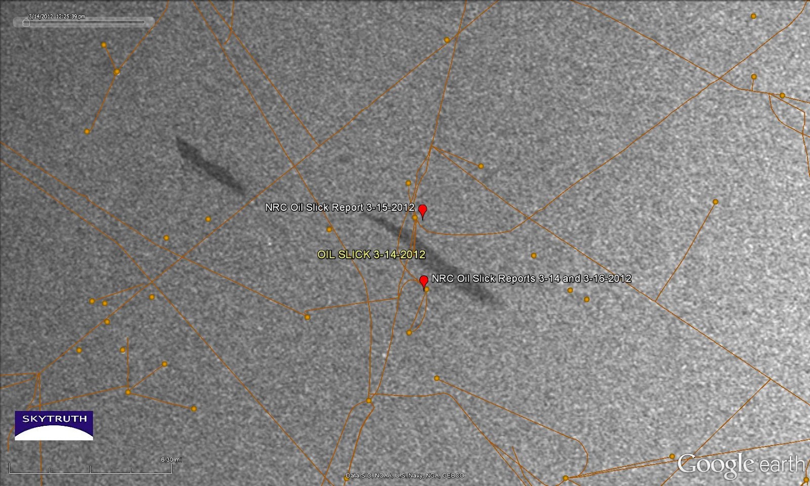 |
| Radar satellite image taken March 14, 2012 showing a pair of small slicks near the vicinity of oil slick sightings reported to the National Response Center on March 14, 15 and 16 (red markers). Orange lines and dots are pipelines and platforms. Image courtesy European Space Agency. |
If anybody wants to
swing on by and take a look, the center of the slick at right is located
at 28.197404° North latitude / 92.783588° West longitude.
[[Location:28.197404,-92.783588]]
Friday, March 16, 2012
Chevron Reports Minor Slick From Leak in Campos Basin, Offshore Brazil
Chevron and Brazilian regulators reported that a small, fresh oil slick has appeared near the site of Chevron's blowout last November
in the deepwater Frade oil field in Brazil's prolific Campos Basin.
This is not entirely unexpected given the nature of the problem that
Chevron had with the well being drilled by the SEDCO 706 rig: an unknown
amount of oil escaped laterally from the well into surrounding bedrock,
and worked its way up to the seafloor along a pre-existing natural
fault. It will take some time for all of that oil to emerge, so we've
been anticipating chronic small oil slicks at this location.
But optical satellite imagery of this area (MODIS and MERIS) have had problems with clouds and haze for the past few days, so we haven't seen any sign of the latest slick. Radar images don't have that problem, but the most recent radar image we have was taken at about 9pm local time on March 9, and it looks clean around the SEDCO 706 site:
[READ MORE...]
[[Location:-21.889431,-39.833091]]
But optical satellite imagery of this area (MODIS and MERIS) have had problems with clouds and haze for the past few days, so we haven't seen any sign of the latest slick. Radar images don't have that problem, but the most recent radar image we have was taken at about 9pm local time on March 9, and it looks clean around the SEDCO 706 site:
 |
| Detail from radar satellite image taken March 9, 2012, showing area of reported Chevron leak. Envisat ASAR image courtesy European Space Agency. |
[[Location:-21.889431,-39.833091]]
Thursday, March 8, 2012
Fire Extinguishes Itself at Chevron Blowout off Nigeria
Chevron reports the fire in the ocean off Nigeria, blazing since their Funiwa-1A gas exploration well blowout occurred on January 16, finally went out on March 2. It's likely that the well "bridged over" and plugged itself, shutting off the flow of natural gas that had been feeding the fire, something every driller hopes for when they lose control of a well.
Work will continue on a relief well so that the failed Funiwa-1A well can be properly plugged and abandoned.
We don't see any signs of the fire on today's MODIS/Terra satellite image.
[[Location:4.356583,5.784562]]
Work will continue on a relief well so that the failed Funiwa-1A well can be properly plugged and abandoned.
We don't see any signs of the fire on today's MODIS/Terra satellite image.
[[Location:4.356583,5.784562]]
Monday, February 27, 2012
Small Slick at Chevron's Blowout off Nigeria
Chevron's gas-well blowout in the Funiwa field off Nigeria continues to burn as efforts are underway to drill a relief well. This Envisat ASAR satellite radar
image taken today (February 27) shows a small slick apparently emanating
from the site where the doomed KS Endeavor rig was drilling.
We've seen a small slick repeatedly at this area since the blowout
occurred. Possibly there are some petroleum liquids coming up with the
gas, and not completely burning off. The slick on today's image is
about 10 miles long:
[[Location:4.356583,5.784562]]
| Small slick apparently emanating from
location of Chevron's Funiwa-1A gas well blowout. Envisat ASAR image
taken February 27, 2012. Image courtesy European Space Agency. |
Small Slick at Platform P-51, Marlim Sul Field, Brazil
An Envisat ASAR radar satellite image taken on February 23, 2012 shows a small slick apparently emanating from Platform P-51 in the Marlim Sul field of the Campos Basin, about 70 miles offshore:
Covering 10 square kilometers, this slick represents a
spill of about 2600 gallons, assuming an average oil slick thickness of
1 micron.
[[Location:-22.635572,-40.093169]]
 |
| Envisat ASAR image taken February 23, 2012 showing small slick apparently emanating from location of Platform P-51. Image courtesy European Space Agency. |
[[Location:-22.635572,-40.093169]]
Thursday, February 23, 2012
Bilge Dumping off Vietnam - February 22, 2012
We've posted
about bilge dumping before - the practice of flushing the oily slop out
of your vessel, straight into the ocean. It's illegal in a lot of
places, but it is very hard to enforce. SkyTruth's daily offshore
monitoring program just caught this fine (awful?) example of bilge
dumping off the coast of Vietnam, in a major north-south shipping lane
about 115 miles offshore:
Zooming in on those black streaks, and turning the image west-up, here's a closer look at this mess:
[READ MORE...]
[[Location:12.820307,111.724137]]
 |
| Envisat ASAR satellite radar image off Vietnam, February 22, 2012. Image courtesy European Space Agency. |
 | |||||||||
| Envisat ASAR image courtesy European Space Agency. |
[READ MORE...]
[[Location:12.820307,111.724137]]
Wednesday, February 8, 2012
Teri noticed a small slick on today's Envisat ASAR radar satellite image covering the site of Chevron's blowout and fire
off the coast of Nigeria. We measure it at about 18.6 kilometers long,
extending about 39 square kilometers. It appears to be very thin.
Assuming the slick is, on average, one micron thick, that amounts to
about 9,500 gallons of some oily substance -- possibly unburned natural
gas condensate, since this was reported by Chevron to be a gas exploration well that was not creating any oil slick:
[READ MORE]
[[Location:4.356583,5.784562]]
| Detail from Envisat ASAR image taken February 8, 2012. Location of blowout marked by rig symbol. Image courtesy European Space Agency. |
[READ MORE]
[[Location:4.356583,5.784562]]
Monday, February 6, 2012
Chevron Blowout and Fire Continues off Nigeria
NASA/MODIS satellite imagery taken yesterday shows that the blowout and fire at a Chevron gas well off the coast of Nigeria continues. That's 20 days and counting. It will take weeks to drill a relief well; according to Chevron the Transocean relief rig is on site, and drilling should begin soon.
Chevron "has moved food and supplies to the communities in the area to recognize the help and support that they have given the company."
Chevron "has moved food and supplies to the communities in the area to recognize the help and support that they have given the company."
| MODIS-Terra
satellite image of Niger Delta showing fire from Chevron offshore well
blowout (red spot at center). Image taken February 5, 2012. Courtesy
NASA/MODIS Rapid Response Team.
[[Location:4.356583,5.784562]]
|
Wednesday, February 1, 2012
Oil Spill from FPSO in Santos Basin, Brazil
Brazil has suffered another oil spill related to FPSO operations, this time in deep water in the Santos Basin. Last week a spill occurred at the Osorio terminal while Campos Basin oil was being offloaded from a shuttle tanker, and fouled the beach near Tramandai. Yesterday, Petrobras reported a spill of about 6700 gallons from the riser pipe of an FPSO in the Santos Basin, forcing them to shut down the country's fifth-most productive oil well.
[[Location:-25.527500,-43.437833]]
[[Location:-25.527500,-43.437833]]
Friday, January 27, 2012
The spill was reported to be about 315 gallons. Video and photos from the affected beaches show one hell of a mess. I guess a little really goes a long way when it comes to an oil spill:
This spill is reminiscent of Shell's recent spill off Nigeria caused when oil leaked from a cracked transfer line between an FPSO and a shuttle tanker. It's possible this Petrobras spill happened at the other end of an FPSO operation, where the shuttle tanker was offloading its cargo to a coastal facility. This is a concern, since FPSOs are now being used in US waters in the Gulf of Mexico for deepwater oil development -- and Petrobras, the world leader in FPSOs, has already had a serious failure at the first FPSO installation under construction in the Gulf.
[READ MORE...]
[[Location:-30.011879,-50.095181]]
Wednesday, January 25, 2012
Drilling to Begin Soon in Deep Water Off Cuba
 |
| Say hello to my little friend: Scarabeo-9 arrives to begin deepwater drilling off Cuba. Photo courtesy Shipspotting.com. |
The Scarabeo-9, a big semisubmersible drill rig owned by Italian company ENI, just built in China, and currently under contract to the Spanish oil company Repsol, has arrived in the Florida Straits off the north coast of Cuba to begin exploratory oil drilling. The rig will begin its work in exploration block N27 (see map after the jump) just 90 miles from Key West, in water about 6,500' deep. That's 1,500' deeper than the site of the BP / Deepwater Horizon spill in the Gulf in 2010.
[READ MORE...]
[[Location:23.541403,82.223840]]
Friday, January 20, 2012
Chevron Blowout and Rig Fire off Nigeria - Small Slick Visible on Radar Today
The K.S. Endeavor jackup drill rig operated for Chevron in
shallow water about 5 miles off the coast of the Niger Delta is
continuing to burn. This blowout probably won't be under control until a
relief well can be drilled. Chevron confirms
the rig had been drilling a gas exploration well they call the Funiwa
Deep-A, with a planned depth of 16,500 feet. But the well had only
reached a depth of 12,945' when the blowout occurred early Monday
morning. That's comparable to the depth of BP's Macondo well that blew
out in the Gulf of Mexico in 2010, launching what would become the
world's worst accidental oil spill.
The Funiwa field has both oil and gas reservoirs. A big question on everyone's mind: Could this lead to a major oil spill? Is there a lot of oil already coming out of the well right now, fueling this blowtorch of a fire? Some have reported sighting slicks and sheen in the vicinity.
Satellite imagery gives us some reason for optimism so far. This Envisat ASAR radar satellite image taken today shows only a very small slick around what we infer to be the location of the burning Endeavor, based on multiple observations of the fire itself on MODIS 7-2-1 satellite images and the bright spots on the radar image that indicate big hunks of metal out in the water (rigs, vessels, platforms):
[READ MORE]
[[Location:4.337242,5.780993]]
The Funiwa field has both oil and gas reservoirs. A big question on everyone's mind: Could this lead to a major oil spill? Is there a lot of oil already coming out of the well right now, fueling this blowtorch of a fire? Some have reported sighting slicks and sheen in the vicinity.
Satellite imagery gives us some reason for optimism so far. This Envisat ASAR radar satellite image taken today shows only a very small slick around what we infer to be the location of the burning Endeavor, based on multiple observations of the fire itself on MODIS 7-2-1 satellite images and the bright spots on the radar image that indicate big hunks of metal out in the water (rigs, vessels, platforms):
| Detail from Envisat ASAR image taken January 20, 2012 showing small slicks in vicinity of burning K.S. Endeavor drill rig. Inferred location of rig shown. Large dark patches along the coast are probably caused by turbid river water entering the ocean. Image courtesy European Space Agency. |
[[Location:4.337242,5.780993]]
Tuesday, January 17, 2012
Satellite Image Shows Heat From Chevron Drill Rig Fire, Offshore Nigeria
| K.S. Endeavor jackup drilling rig burning off Nigeria's coast on January 16, 2012. Photo courtesy Chevron. |
| Detail of MODIS 7-2-1 infrared image along Niger Delta coastline, January 17, 2012. Bright red spot marks inferred location of the burning K.S. Endeavor jackup drill rig. |
[READ MORE]
[[Location:4.352748,5.783680]]
Subscribe to:
Comments (Atom)