Yesterday evening Shell reported sighting a 10-mile by 1-mile oil
slick between two of their major deepwater oil production platforms, Ursa and Mars. This is located in the Mississippi Canyon area of the
Gulf, 130 miles south of New Orleans and about 60 miles beyond the tip
of the Mississippi Delta, in water about 3,200' deep.
Yesterday's low resolution MODIS/Terra satellite image of the area, shot at 16:50 UTC (10:50 am local time)
shows what appears to be a narrow, 17-mile-long slick in the vicinity
of the two platforms. We often see slicks from known natural oil seeps
that are about this size; some in the Green Canyon area to the west show
up well on this same image. Low clouds and their shadows are scattered
across the lower half of this view:
[READ MORE...]
[[Location: 28.204381,-89.258767]]
This blog is the publishing outlet for alerts about ongoing environmental incidents and pollution events
Thursday, April 12, 2012
Tuesday, April 10, 2012
Gas Pipeline Explosion and Fire - Vermilion Parish, Louisiana
SkyTruth Alerts
gave us a heads up that there was an explosion and fire around noon
yesterday in the marshes of Vermilion Parish, Louisiana. One caller to
the National Response Center noted flames shooting 150' into the air; another caller, perhaps a bit more excited, claimed 800'. At
about the same time, a caller from Texas Gas Transmission Co. detected a
huge drop in pressure in one of their gas pipelines, while noting a fireball in the marsh in the vicinity of the pipeline. The fire was burning so hot that it shows up as a fuzzy red spot in this low-resolution MODIS/Terra band 7-2-1 satellite image, taken yesterday at 1pm local time:
Friday, April 6, 2012
Gas Well Blowout in the North Sea - Small Slick on April 4
The out-of-control well owned by French company Total in the central
North Sea's Elgin field is still spewing natural gas into the air. We noted a small slick at this site
on a radar satellite image taken March 27. Another image, taken on
April 4, also shows a somewhat smaller slick (see image below). This is
probably caused by natural-gas condensate, a volatile and toxic
hydrocarbon liquid that evaporates relatively quickly. We don't see any
reason to expect this incident to morph into a significant oil spill.
[READ MORE...]
[[Location: 57.011667,1.837778]]
| Radar satellite image showing small slick at North Sea blowout site, taken on April 4, 2012 at 9:29 pm local time. Envisat ASAR image courtesy European Space Agency. |
[[Location: 57.011667,1.837778]]
Thursday, April 5, 2012
Cuba Offshore Drilling Rig Spotted on Radar - Small Slick Reported
The big semisubmersible drill rig, built in China and now drilling a
deepwater oil well for the Spanish company Repsol in the Florida Straits
off Cuba (hey, it is a global industry), has finally made an appearance
on a radar satellite image. This Envisat ASAR image,
shot at 11:43 pm local time on March 30, shows a trio of very bright
spots about 17 miles north-northwest of Havana. We think the largest of
these spots, with an interesting cross-shaped "ringing" pattern often seen on radar images of big, boxy metal objects, is the Scarabeo-9 rig. The other two spots may be crew vessels or workboats:
[READ MORE...]
[[Location: 23.374496,-82.492283]]
| Image courtesy European Space Agency. |
[[Location: 23.374496,-82.492283]]
Wednesday, March 28, 2012
Gas Well Blowout in the North Sea
On March 26, Total reported a gas leak that forced them to evacuate more
than 200 workers from a production platform in the Elgin field of the
central North Sea, about 150 miles east of Aberdeen, Scotland. The Oil Drum has compiled excellent information about this serious ongoing incident. This
Envisat ASAR radar satellite image, taken yesterday at about 9:23 pm
local time, shows a patchy slick covering about 89 square kilometers (34 square miles).
The platform itself appears as a very bright spot on the radar image
but it's covered up by our yellow rig icon marking the location:
[READ MORE]
[[Location: 57.011667,1.837778]]
| Envisat ASAR image courtesy European Space Agency. |
[[Location: 57.011667,1.837778]]
Thursday, March 22, 2012
Slicks in Campos Basin, Offshore Brazil - March 20, 2012
This Envisat ASAR radar satellite image of the Campos Basin,
taken at 9:18 pm local time on March 20, shows what appear to be long,
narrow slicks emanating from several Petrobras production platforms and FPSOs:
![]() |
| March 201, 2012 Envisat ASAR radar satellite image courtesy European Space Agency. |
This
is a complex image. Platforms, FPSOs, drill rigs and vessels appear as
bright spots on radar. The large, indistinct dark areas in the upper
part of the image are also slicks, but not caused by oil (a "slick" is
any patch of smooth water, appearing dark on a radar image). Instead,
these patches are probably caused by areas of very low wind speed,
and/or by heavy rainfall. Sea-surface wind data, taken almost the same time as the radar image above, indicate there was unsettled stormy weather in the area.
[[Location:-22.593539,-40.188575]]
Monday, March 19, 2012
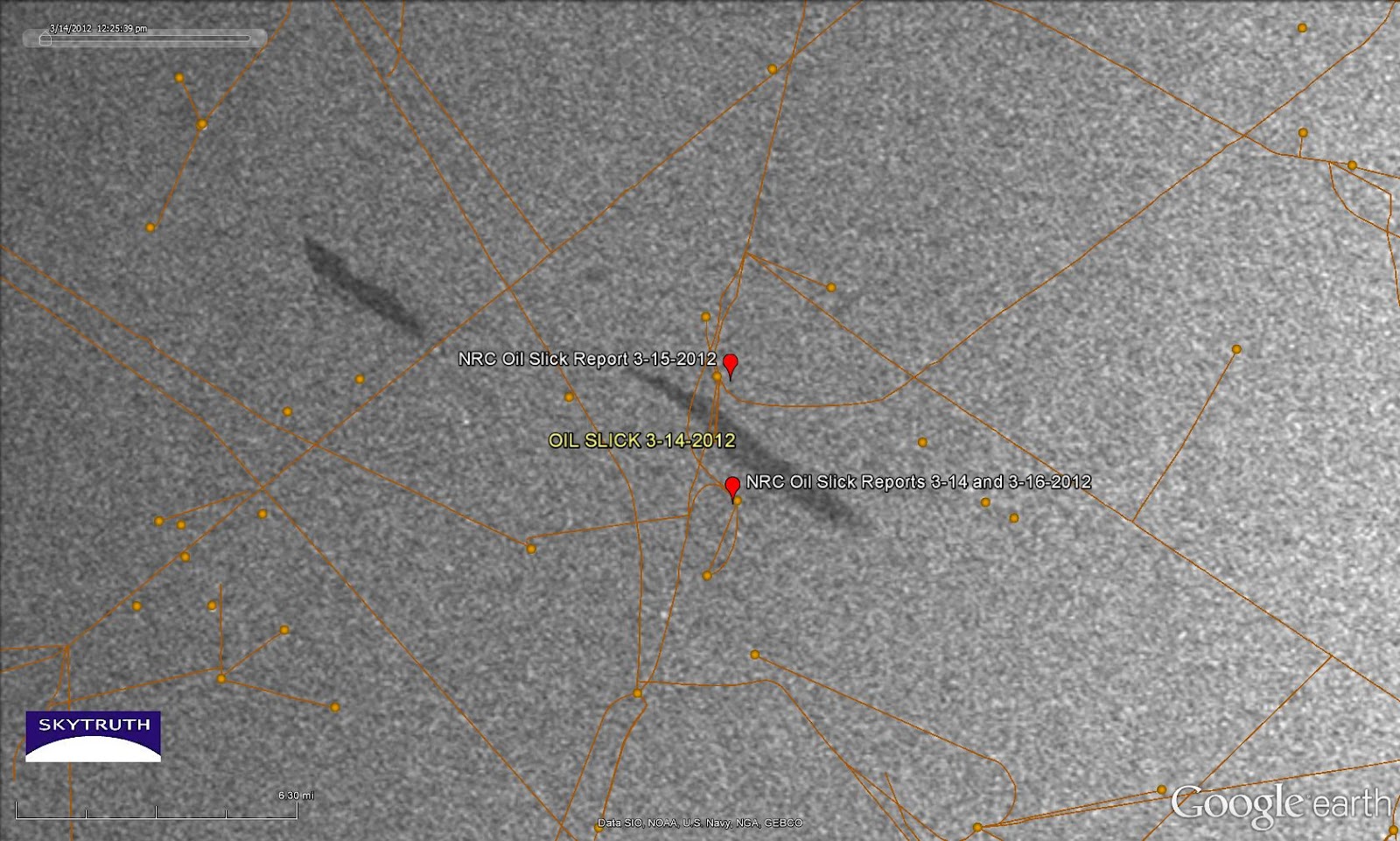
Mystery Slicks in Central Gulf - East Cameron South, Block 321
Every now and then we see something in SkyTruth Alerts
that catches our eye. For the past few days we've noticed repeated
reports of an unknown oil slick sighted near some platforms near Block
321 in the East Cameron (South Addition) area of the central Gulf of
Mexico, about 92 miles off the Louisiana coast. We also see two slicks
in the vicinity on an Envisat ASAR satellite radar image taken about
noon local time on March 14. The slicks aren't particularly big, on the
image or in the reports, but their persistence in the area under strong winds blowing steadily from the southeast
suggests that there is a continuous source of oil leaking at this
site. This is close to a major international shipping lane for the port
of Houston, and there are also quite a few platforms and pipelines in
the neighborhood:
back in 1978). Oil slick sightings were reported to the National Response Center, probably by personnel on the nearby platforms, on March 14, 15 and 16. No source or cause is indicated in the reports. We don't know if there is any active drilling occurring in the area.
If anybody wants to
swing on by and take a look, the center of the slick at right is located
at 28.197404° North latitude / 92.783588° West longitude.
[[Location:28.197404,-92.783588]]
Subscribe to:
Posts (Atom)