Tuesday, November 15, 2011

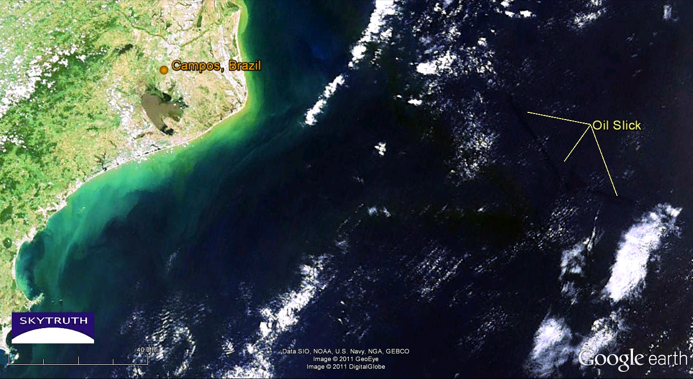
130 Mile Oil Slick from Chevron OIl Spill off Brazil

We've been tracking the oil spill reported off Brazil a few days ago, in the Frade field operated by Chevron in the Campos Basin, Brazil's most productive area of offshore production, and a place where many deepwater technology milestones have been made for offshore oil production.  Chevron claimed the oil slick was being caused by a natural oil seep on the seafloor, but they suspended drilling on a well in the field.  Brazilian authorities quickly disputed that a natural seep was the cause.  And yesterday Chevron admitted the possibility that something went wrong at their drillsite.  According to today's news release from Brazilian authorities, Chevron is trying to kill the well - indicating a loss of well control and blowout. 18 response vessels are on the scene, and Chevron reports the well is leaking about 8,400 - 13,860 gallons  (200 -330 barrels) per day.

MODIS/Aqua satellite image shows growing oil slick in the deepwater Campos Basin off Brazil.  Image taken around midday on November 12, 2011.

[[Location: -21.901,-39.822]]
[[KML:https://docs.google.com/uc?id=0B9UdbG3ddaeCYWVmOTljY2QtNjE4NC00YzMxLTk4MTYtZTJhZGRiODA5NmUx&export=download&hl=en_US]]


Friday, November 11, 2011

56 Mile Oil Slick Observed off Brazil

Today's MERIS satellite image (courtesy of the European Space Agency) shows an apparent slick that's now about 56 miles long off the coast of Brazil in the Campos Basin:
MERIS satellite image showing slick in Campos Basin off Brazil, November 11, 2011. Image courtesy European Space Agency.
As in the MODIS images shot two days ago, this slick appears to be continuously emanating from a point source at the north end. Today Chevron claimed it was being caused by a natural oil seep, not any leak or problem associated with the offshore field that they operate. 

It is possible, but call us skeptical.  From my previous years working as an exploration geologist I know there are natural seeps off Brazil (that was a study I did for BP back in the day...). But I've never seen a natural seep create a slick this large on a satellite image.


[[Location: -22.117926, -39.664834]]

"Fracking Pit" Spill Reported near Salem, West Virginia

Following up on this November 9 report about a spill of "fracking fluid" from a pit located about a mile and a half to the north east of Salem, WV in Harrison county.  Note that we placed the original report in the town of Salem because we had to approximate the location since no specific latitude and longitude were given in the report. This report shows where we believe the actual location of the incident to be.

Here's what we know:

The operator of the site is Antero Resources Bluestone, LLC which sits on property reportedly owned by Mary Post and Robert Haught. Several drilling permits on this property were issued over the past few years, and several permits were issued and then canceled. The most recent permit we see in the WV Permit Data site is API number 033-05540 which was approved on 4/19/2011. The prior permits for this farm were signed by Hall Drilling. So far, we haven't found any actual 'permit commenced' filing for any permit issued on this property (we believe that a "permit commenced" filing indicates the start of drilling activity). In the most recent permit, the current operator is listed as Antero Resources Bluestone LLC.   A little online research reveals that Bluestone LLC was acquired by Antero Resources last December. According to that press release: "Sam Ross, Mike Hall and the Bluestone team have created quite a valuable asset in the play and we congratulate them on their success." In the WV Permit Data search, we found that Michael Hall was the contact person for Hall Drilling, LLC. So we conclude that Hall became Bluestone LLC, and was then taken over by Antero Resources.


[[Location: 39.2997278,-80.5388131]]

Thursday, November 10, 2011

Oil Spill off Brazil Seen On Satellite Images

We don't have much information on this yet but Chevron is reporting an oil spill in their Frade field in the Campos Basin off Brazil.  Two MODIS satellite images from NASA, taken yesterday, show an apparent oil slick about 35 miles long and covering about 180 square kilometers, 80 miles offshore due east of the city of Campos. Assuming this slick is only one micron (1/1000th of a millimeter) thick, then it represents about 47,000 gallons.


November 9, 2011 MODIS/Terra image of oil slick off Campos, Brazil. Image courtesy NASA/Rapid Response Team.


[[Location: -22.117926, -39.664834]]

Fire Reported in Gulf of Mexico Near BP and Shell's Na Kika Offshore Drilling Site

Once again an airline pilot (or observant passenger) has reported seeing a fire in the Gulf of Mexico.  This was reported to the National Response Center at about 8:19 pm on November 6, at a location in the deepwater Gulf about 12 miles southeast of the site of last year's BP oil spill.  It's also about 11 miles north of a fire reported on September 26 that we covered in this blog.
Location of fires in the Gulf recently reported to the National Response Center in the general vicinity of the Na Kika deepwater development project operated by BP and Shell. Platforms are orange dots; seafloor pipelines are orange lines.


[[Location: 28.633333, -88.216667]]

Tuesday, October 18, 2011

Hydrogen Cyanide Release in Delaware City, DE

There is an ongoing release of potentially lethal hydrogen cyanide into the atmosphere at the Delaware City Refinery in Delaware City, DE.  The release started with a mechanical failure on October 2  and has continued for the last two weeks, currently reported to be releasing up to 200 pounds per day of hydrogen cyanide into the air. In addition to SkyTruth Alerts, this ongoing release is also reported in the Delaware Environmental Release Notification System.


Delaware City Refinery - site of the ongoing release

To be notified of additional reports at this location, you can follow this incident:
 [[Location: 39.587, -75.63]]

Tuesday, October 4, 2011

Beautiful Gulf Image Today - MODIS/Terra

Thought I'd share this pretty satellite image of the Gulf of Mexico, taken at about 10:30 am local time this morning. No sign of the smoke plume we reported on from October 2, which was also visible on yesterday's Terra and Aqua images.

So enjoy.  Click to get the larger version, formatted to be 16:9 so it makes a sweet background for most computer monitors...!